You are here: Home > Network List > TA - USArray Transportable Network (new EarthScope stations) Stations List
> Station J01E Myrtle Point, OR, USA > Earthquake Result Viewer
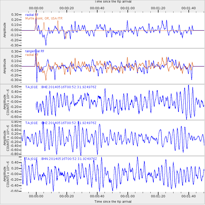
J01E Myrtle Point, OR, USA - Earthquake Result Viewer
*The percent match for this event was below the threshold and hence no stack was calculated.
| Earthquake location: |
Southeast Of Loyalty Islands |
| Earthquake latitude/longitude: |
-22.6/173.0 |
| Earthquake time(UTC): |
2014/05/16 (136) 00:40:17 GMT |
| Earthquake Depth: |
19 km |
| Earthquake Magnitude: |
5.5 MW |
| Earthquake Catalog/Contributor: |
ISC/ISC |
|
| Network: |
TA USArray Transportable Network (new EarthScope stations) |
| Station: |
J01E Myrtle Point, OR, USA |
| Lat/Lon: |
43.16 N/123.93 W |
| Elevation: |
128 m |
|
| Distance: |
87.4 deg |
| Az: |
40.772 deg |
| Baz: |
235.537 deg |
| Ray Param: |
$rayparam |
*The percent match for this event was below the threshold and hence was not used in the summary stack. |
|
| Radial Match: |
52.280094 % |
| Radial Bump: |
400 |
| Transverse Match: |
44.367477 % |
| Transverse Bump: |
400 |
| SOD ConfigId: |
3390531 |
| Insert Time: |
2019-04-11 21:55:57.885 +0000 |
| GWidth: |
2.5 |
| Max Bumps: |
400 |
| Tol: |
0.001 |
|
Signal To Noise
| Channel | StoN | STA | LTA |
| TA:J01E: :BHZ:20140516T00:52:31.924976Z | 1.4636322 | 3.4071167E-7 | 2.3278503E-7 |
| TA:J01E: :BHN:20140516T00:52:31.924976Z | 1.039533 | 2.1640692E-7 | 2.0817706E-7 |
| TA:J01E: :BHE:20140516T00:52:31.924976Z | 1.0934277 | 2.647394E-7 | 2.4211883E-7 |
| Arrivals |
| Ps | |
| PpPs | |
| PsPs/PpSs | |


