You are here: Home > Network List > G - GEOSCOPE Stations List
> Station SCZ Chualar Canyon, Santa Cruz, California, U.S.A. > Earthquake Result Viewer
SCZ Chualar Canyon, Santa Cruz, California, U.S.A. - Earthquake Result Viewer
| Earthquake location: |
Northern Bolivia |
| Earthquake latitude/longitude: |
-13.8/-67.6 |
| Earthquake time(UTC): |
1994/06/09 (160) 00:33:16 GMT |
| Earthquake Depth: |
637 km |
| Earthquake Magnitude: |
6.9 MB, 6.8 MS, 8.3 UNKNOWN, 8.2 MW |
| Earthquake Catalog/Contributor: |
WHDF/NEIC |
|
| Network: |
G GEOSCOPE |
| Station: |
SCZ Chualar Canyon, Santa Cruz, California, U.S.A. |
| Lat/Lon: |
36.60 N/121.40 W |
| Elevation: |
261 m |
|
| Distance: |
71.3 deg |
| Az: |
316.698 deg |
| Baz: |
124.123 deg |
| Ray Param: |
0.052173242 |
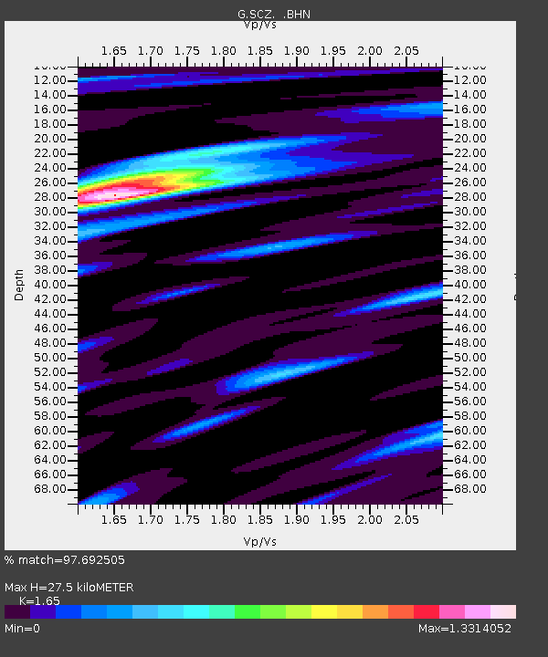
| Estimated Moho Depth: |
27.5 km |
| Estimated Crust Vp/Vs: |
1.65 |
| Assumed Crust Vp: |
6.391 km/s |
| Estimated Crust Vs: |
3.873 km/s |
| Estimated Crust Poisson's Ratio: |
0.21 |
|
| Radial Match: |
97.692505 % |
| Radial Bump: |
400 |
| Transverse Match: |
96.284424 % |
| Transverse Bump: |
400 |
| SOD ConfigId: |
16938 |
| Insert Time: |
2010-02-26 23:49:23.614 +0000 |
| GWidth: |
2.5 |
| Max Bumps: |
400 |
| Tol: |
0.001 |
|

Signal To Noise
| Channel | StoN | STA | LTA |
| G:SCZ: :BHN:19940609T00:43:02.748999Z | 27.64452 | 5.13746E-6 | 1.8584008E-7 |
| G:SCZ: :BHE:19940609T00:43:02.748999Z | 17.547604 | 7.805368E-6 | 4.4481106E-7 |
| G:SCZ: :BHZ:19940609T00:43:02.748999Z | 24.700237 | 2.7834638E-5 | 1.1268976E-6 |
| Arrivals |
| Ps | 2.9 SECOND |
| PpPs | 11 SECOND |
| PsPs/PpSs | 14 SECOND |


