You are here: Home > Network List > TA - USArray Transportable Network (new EarthScope stations) Stations List
> Station G43A Wallace, MI, USA > Earthquake Result Viewer
G43A Wallace, MI, USA - Earthquake Result Viewer
| Earthquake location: |
Komandorskiye Ostrova Region |
| Earthquake latitude/longitude: |
54.4/168.9 |
| Earthquake time(UTC): |
2012/05/29 (150) 02:40:53 GMT |
| Earthquake Depth: |
10 km |
| Earthquake Magnitude: |
5.5 MS, 5.4 MB, 5.6 MW, 5.6 MW |
| Earthquake Catalog/Contributor: |
WHDF/NEIC |
|
| Network: |
TA USArray Transportable Network (new EarthScope stations) |
| Station: |
G43A Wallace, MI, USA |
| Lat/Lon: |
45.26 N/87.69 W |
| Elevation: |
213 m |
|
| Distance: |
61.4 deg |
| Az: |
51.484 deg |
| Baz: |
319.592 deg |
| Ray Param: |
0.06088231 |
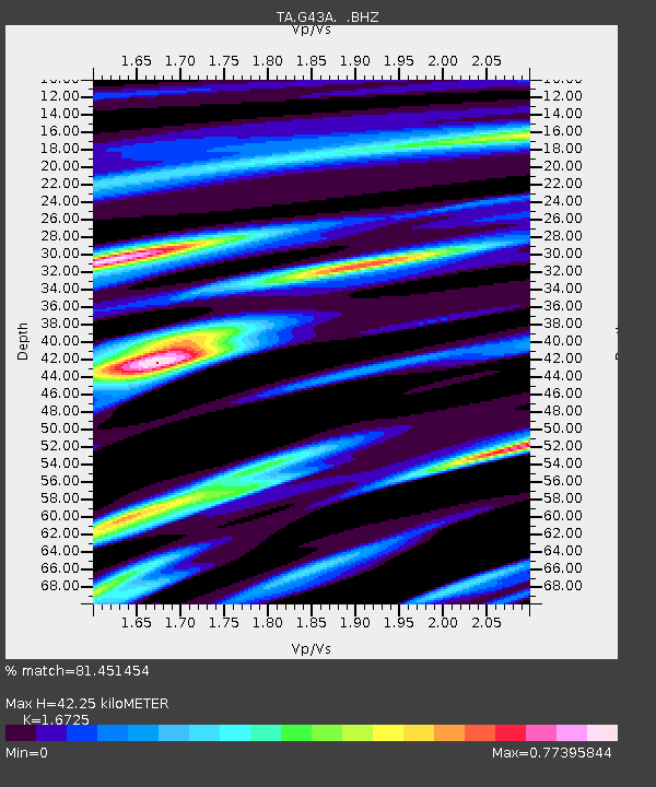
| Estimated Moho Depth: |
42.25 km |
| Estimated Crust Vp/Vs: |
1.67 |
| Assumed Crust Vp: |
6.53 km/s |
| Estimated Crust Vs: |
3.905 km/s |
| Estimated Crust Poisson's Ratio: |
0.22 |
|
| Radial Match: |
81.451454 % |
| Radial Bump: |
367 |
| Transverse Match: |
65.5247 % |
| Transverse Bump: |
400 |
| SOD ConfigId: |
455246 |
| Insert Time: |
2012-09-25 01:32:16.573 +0000 |
| GWidth: |
2.5 |
| Max Bumps: |
400 |
| Tol: |
0.001 |
|
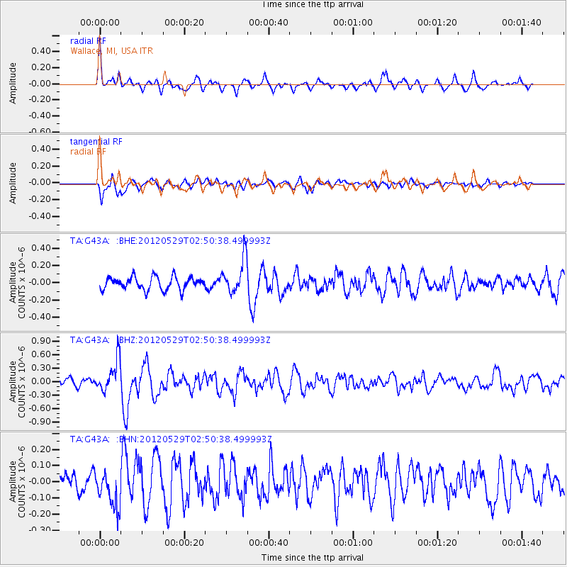
Signal To Noise
| Channel | StoN | STA | LTA |
| TA:G43A: :BHZ:20120529T02:50:38.499993Z | 4.6634693 | 3.703099E-7 | 7.9406526E-8 |
| TA:G43A: :BHN:20120529T02:50:38.499993Z | 1.8303472 | 1.205006E-7 | 6.583484E-8 |
| TA:G43A: :BHE:20120529T02:50:38.499993Z | 2.805483 | 2.0898568E-7 | 7.4491865E-8 |
| Arrivals |
| Ps | 4.6 SECOND |
| PpPs | 16 SECOND |
| PsPs/PpSs | 21 SECOND |


