You are here: Home > Network List > G - GEOSCOPE Stations List
> Station SCZ Chualar Canyon, Santa Cruz, California, U.S.A. > Earthquake Result Viewer
SCZ Chualar Canyon, Santa Cruz, California, U.S.A. - Earthquake Result Viewer

| Earthquake location: |
Off Coast Of Oaxaca, Mexico |
| Earthquake latitude/longitude: |
14.9/-97.3 |
| Earthquake time(UTC): |
1994/07/04 (185) 21:36:44 GMT |
| Earthquake Depth: |
33 km |
| Earthquake Magnitude: |
6.1 MB, 6.1 MS, 6.5 UNKNOWN, 6.5 MD |
| Earthquake Catalog/Contributor: |
WHDF/NEIC |
|
| Network: |
G GEOSCOPE |
| Station: |
SCZ Chualar Canyon, Santa Cruz, California, U.S.A. |
| Lat/Lon: |
36.60 N/121.40 W |
| Elevation: |
261 m |
|
| Distance: |
30.4 deg |
| Az: |
319.586 deg |
| Baz: |
128.857 deg |
| Ray Param: |
0.07930419 |
| Estimated Moho Depth: |
28.0 km |
| Estimated Crust Vp/Vs: |
1.61 |
| Assumed Crust Vp: |
6.391 km/s |
| Estimated Crust Vs: |
3.982 km/s |
| Estimated Crust Poisson's Ratio: |
0.18 |
|
| Radial Match: |
84.342125 % |
| Radial Bump: |
368 |
| Transverse Match: |
49.001343 % |
| Transverse Bump: |
327 |
| SOD ConfigId: |
16938 |
| Insert Time: |
2010-02-26 23:49:25.039 +0000 |
| GWidth: |
2.5 |
| Max Bumps: |
400 |
| Tol: |
0.001 |
|
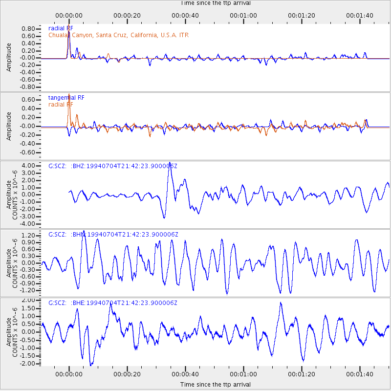
Signal To Noise
| Channel | StoN | STA | LTA |
| G:SCZ: :BHN:19940704T21:42:23.900006Z | 3.408803 | 6.0800926E-7 | 1.7836446E-7 |
| G:SCZ: :BHE:19940704T21:42:23.900006Z | 1.9807233 | 8.683231E-7 | 4.383869E-7 |
| G:SCZ: :BHZ:19940704T21:42:23.900006Z | 6.186914 | 2.028471E-6 | 3.2786474E-7 |
| Arrivals |
| Ps | 2.9 SECOND |
| PpPs | 10 SECOND |
| PsPs/PpSs | 13 SECOND |


