You are here: Home > Network List > TA - USArray Transportable Network (new EarthScope stations) Stations List
> Station N45A Kentland, IN, USA > Earthquake Result Viewer
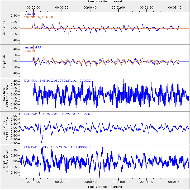
N45A Kentland, IN, USA - Earthquake Result Viewer
*The percent match for this event was below the threshold and hence no stack was calculated.
| Earthquake location: |
Komandorskiye Ostrova Region |
| Earthquake latitude/longitude: |
54.4/168.9 |
| Earthquake time(UTC): |
2012/05/29 (150) 02:40:53 GMT |
| Earthquake Depth: |
10 km |
| Earthquake Magnitude: |
5.5 MS, 5.4 MB, 5.6 MW, 5.6 MW |
| Earthquake Catalog/Contributor: |
WHDF/NEIC |
|
| Network: |
TA USArray Transportable Network (new EarthScope stations) |
| Station: |
N45A Kentland, IN, USA |
| Lat/Lon: |
40.85 N/87.51 W |
| Elevation: |
206 m |
|
| Distance: |
64.9 deg |
| Az: |
54.526 deg |
| Baz: |
321.085 deg |
| Ray Param: |
$rayparam |
*The percent match for this event was below the threshold and hence was not used in the summary stack. |
|
| Radial Match: |
77.42975 % |
| Radial Bump: |
398 |
| Transverse Match: |
54.305508 % |
| Transverse Bump: |
400 |
| SOD ConfigId: |
455246 |
| Insert Time: |
2012-09-25 01:33:45.935 +0000 |
| GWidth: |
2.5 |
| Max Bumps: |
400 |
| Tol: |
0.001 |
|
Signal To Noise
| Channel | StoN | STA | LTA |
| TA:N45A: :BHZ:20120529T02:51:01.499993Z | 3.5059488 | 4.2149327E-7 | 1.2022231E-7 |
| TA:N45A: :BHN:20120529T02:51:01.499993Z | 2.1259904 | 1.8786574E-7 | 8.836623E-8 |
| TA:N45A: :BHE:20120529T02:51:01.499993Z | 1.1968868 | 1.7944073E-7 | 1.499229E-7 |
| Arrivals |
| Ps | |
| PpPs | |
| PsPs/PpSs | |


