You are here: Home > Network List > TA - USArray Transportable Network (new EarthScope stations) Stations List
> Station X46A Booneville, MS, USA > Earthquake Result Viewer
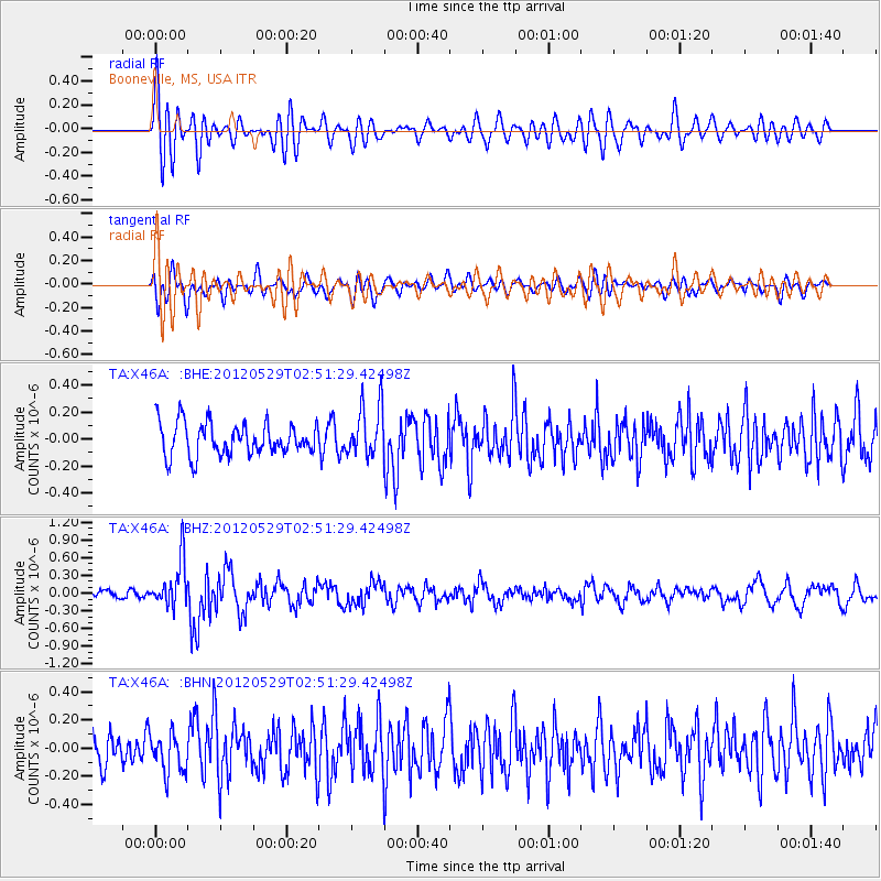
X46A Booneville, MS, USA - Earthquake Result Viewer
*The percent match for this event was below the threshold and hence no stack was calculated.
| Earthquake location: |
Komandorskiye Ostrova Region |
| Earthquake latitude/longitude: |
54.4/168.9 |
| Earthquake time(UTC): |
2012/05/29 (150) 02:40:53 GMT |
| Earthquake Depth: |
10 km |
| Earthquake Magnitude: |
5.5 MS, 5.4 MB, 5.6 MW, 5.6 MW |
| Earthquake Catalog/Contributor: |
WHDF/NEIC |
|
| Network: |
TA USArray Transportable Network (new EarthScope stations) |
| Station: |
X46A Booneville, MS, USA |
| Lat/Lon: |
34.56 N/88.58 W |
| Elevation: |
150 m |
|
| Distance: |
69.3 deg |
| Az: |
59.474 deg |
| Baz: |
322.358 deg |
| Ray Param: |
$rayparam |
*The percent match for this event was below the threshold and hence was not used in the summary stack. |
|
| Radial Match: |
64.293045 % |
| Radial Bump: |
400 |
| Transverse Match: |
58.054134 % |
| Transverse Bump: |
400 |
| SOD ConfigId: |
455246 |
| Insert Time: |
2012-09-25 01:36:18.779 +0000 |
| GWidth: |
2.5 |
| Max Bumps: |
400 |
| Tol: |
0.001 |
|
Signal To Noise
| Channel | StoN | STA | LTA |
| TA:X46A: :BHZ:20120529T02:51:29.42498Z | 4.3067293 | 3.9487261E-7 | 9.168735E-8 |
| TA:X46A: :BHN:20120529T02:51:29.42498Z | 0.87649137 | 1.3642656E-7 | 1.5565078E-7 |
| TA:X46A: :BHE:20120529T02:51:29.42498Z | 1.5828274 | 1.8922286E-7 | 1.1954737E-7 |
| Arrivals |
| Ps | |
| PpPs | |
| PsPs/PpSs | |


