You are here: Home > Network List > G - GEOSCOPE Stations List
> Station SCZ Chualar Canyon, Santa Cruz, California, U.S.A. > Earthquake Result Viewer
SCZ Chualar Canyon, Santa Cruz, California, U.S.A. - Earthquake Result Viewer
| Earthquake location: |
Santa Cruz Islands |
| Earthquake latitude/longitude: |
-11.5/166.4 |
| Earthquake time(UTC): |
1994/08/22 (234) 17:26:38 GMT |
| Earthquake Depth: |
148 km |
| Earthquake Magnitude: |
6.1 MB, 6.4 UNKNOWN, 6.1 MW |
| Earthquake Catalog/Contributor: |
WHDF/NEIC |
|
| Network: |
G GEOSCOPE |
| Station: |
SCZ Chualar Canyon, Santa Cruz, California, U.S.A. |
| Lat/Lon: |
36.60 N/121.40 W |
| Elevation: |
261 m |
|
| Distance: |
82.9 deg |
| Az: |
50.541 deg |
| Baz: |
250.12 deg |
| Ray Param: |
0.046233274 |
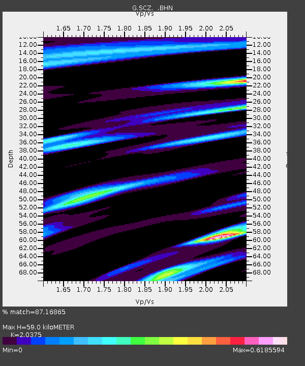
| Estimated Moho Depth: |
59.0 km |
| Estimated Crust Vp/Vs: |
2.04 |
| Assumed Crust Vp: |
6.391 km/s |
| Estimated Crust Vs: |
3.137 km/s |
| Estimated Crust Poisson's Ratio: |
0.34 |
|
| Radial Match: |
87.16865 % |
| Radial Bump: |
355 |
| Transverse Match: |
85.28451 % |
| Transverse Bump: |
400 |
| SOD ConfigId: |
17000 |
| Insert Time: |
2010-02-26 23:49:35.971 +0000 |
| GWidth: |
2.5 |
| Max Bumps: |
400 |
| Tol: |
0.001 |
|

Signal To Noise
| Channel | StoN | STA | LTA |
| G:SCZ: :BHN:19940822T17:38:15.150012Z | 2.0220406 | 2.8218477E-7 | 1.3955444E-7 |
| G:SCZ: :BHE:19940822T17:38:15.150012Z | 5.2510104 | 5.7070963E-7 | 1.08685676E-7 |
| G:SCZ: :BHZ:19940822T17:38:15.150012Z | 16.70485 | 2.0465275E-6 | 1.2251098E-7 |
| Arrivals |
| Ps | 9.8 SECOND |
| PpPs | 27 SECOND |
| PsPs/PpSs | 37 SECOND |


