You are here: Home > Network List > TA - USArray Transportable Network (new EarthScope stations) Stations List
> Station T52A Hallie, KY, USA > Earthquake Result Viewer
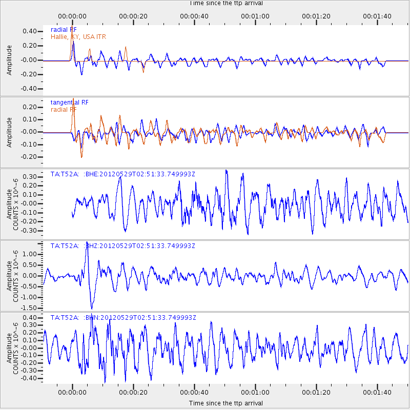
T52A Hallie, KY, USA - Earthquake Result Viewer
*The percent match for this event was below the threshold and hence no stack was calculated.
| Earthquake location: |
Komandorskiye Ostrova Region |
| Earthquake latitude/longitude: |
54.4/168.9 |
| Earthquake time(UTC): |
2012/05/29 (150) 02:40:53 GMT |
| Earthquake Depth: |
10 km |
| Earthquake Magnitude: |
5.5 MS, 5.4 MB, 5.6 MW, 5.6 MW |
| Earthquake Catalog/Contributor: |
WHDF/NEIC |
|
| Network: |
TA USArray Transportable Network (new EarthScope stations) |
| Station: |
T52A Hallie, KY, USA |
| Lat/Lon: |
37.11 N/82.99 W |
| Elevation: |
436 m |
|
| Distance: |
70.0 deg |
| Az: |
53.965 deg |
| Baz: |
323.708 deg |
| Ray Param: |
$rayparam |
*The percent match for this event was below the threshold and hence was not used in the summary stack. |
|
| Radial Match: |
68.02826 % |
| Radial Bump: |
400 |
| Transverse Match: |
68.60043 % |
| Transverse Bump: |
400 |
| SOD ConfigId: |
455246 |
| Insert Time: |
2012-09-25 01:40:47.120 +0000 |
| GWidth: |
2.5 |
| Max Bumps: |
400 |
| Tol: |
0.001 |
|
Signal To Noise
| Channel | StoN | STA | LTA |
| TA:T52A: :BHZ:20120529T02:51:33.749993Z | 2.4575326 | 4.9072526E-7 | 1.9968208E-7 |
| TA:T52A: :BHN:20120529T02:51:33.749993Z | 1.1684253 | 1.8424504E-7 | 1.5768661E-7 |
| TA:T52A: :BHE:20120529T02:51:33.749993Z | 0.6111532 | 7.638451E-8 | 1.2498423E-7 |
| Arrivals |
| Ps | |
| PpPs | |
| PsPs/PpSs | |


