You are here: Home > Network List > TA - USArray Transportable Network (new EarthScope stations) Stations List
> Station V53A Saluda, NC, USA > Earthquake Result Viewer
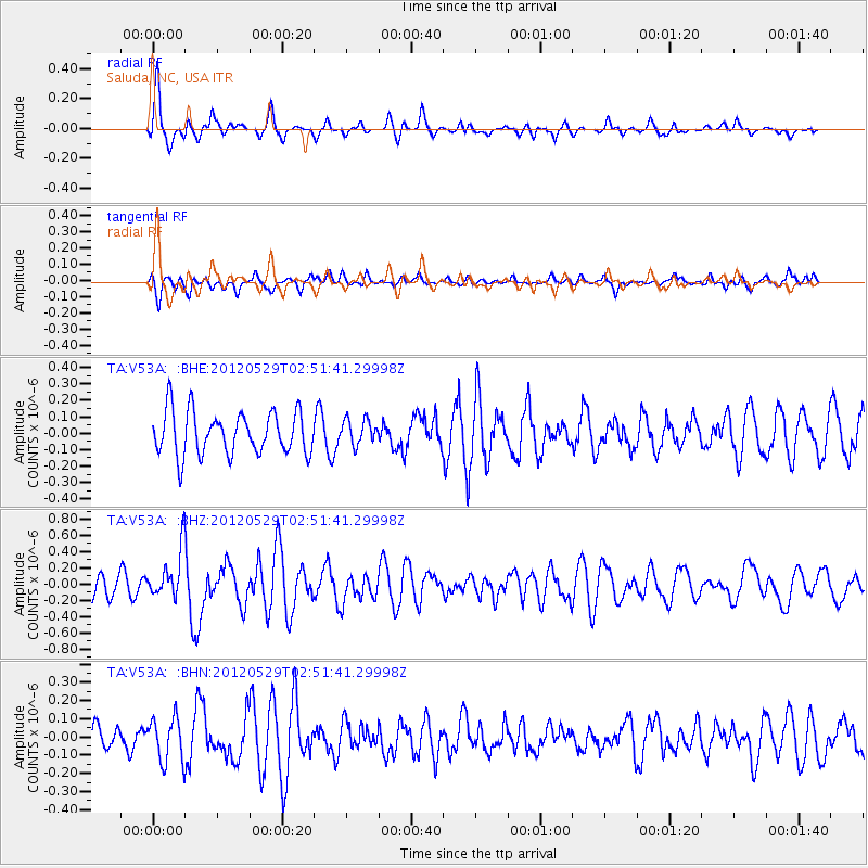
V53A Saluda, NC, USA - Earthquake Result Viewer
*The percent match for this event was below the threshold and hence no stack was calculated.
| Earthquake location: |
Komandorskiye Ostrova Region |
| Earthquake latitude/longitude: |
54.4/168.9 |
| Earthquake time(UTC): |
2012/05/29 (150) 02:40:53 GMT |
| Earthquake Depth: |
10 km |
| Earthquake Magnitude: |
5.5 MS, 5.4 MB, 5.6 MW, 5.6 MW |
| Earthquake Catalog/Contributor: |
WHDF/NEIC |
|
| Network: |
TA USArray Transportable Network (new EarthScope stations) |
| Station: |
V53A Saluda, NC, USA |
| Lat/Lon: |
35.67 N/82.81 W |
| Elevation: |
681 m |
|
| Distance: |
71.2 deg |
| Az: |
54.743 deg |
| Baz: |
324.068 deg |
| Ray Param: |
$rayparam |
*The percent match for this event was below the threshold and hence was not used in the summary stack. |
|
| Radial Match: |
76.69192 % |
| Radial Bump: |
400 |
| Transverse Match: |
49.540665 % |
| Transverse Bump: |
400 |
| SOD ConfigId: |
455246 |
| Insert Time: |
2012-09-25 01:41:02.744 +0000 |
| GWidth: |
2.5 |
| Max Bumps: |
400 |
| Tol: |
0.001 |
|
Signal To Noise
| Channel | StoN | STA | LTA |
| TA:V53A: :BHZ:20120529T02:51:41.29998Z | 2.0053196 | 2.9715704E-7 | 1.4818437E-7 |
| TA:V53A: :BHN:20120529T02:51:41.29998Z | 1.5040177 | 1.202038E-7 | 7.99218E-8 |
| TA:V53A: :BHE:20120529T02:51:41.29998Z | 0.57967895 | 7.561691E-8 | 1.3044618E-7 |
| Arrivals |
| Ps | |
| PpPs | |
| PsPs/PpSs | |


