You are here: Home > Network List > G - GEOSCOPE Stations List
> Station SCZ Chualar Canyon, Santa Cruz, California, U.S.A. > Earthquake Result Viewer
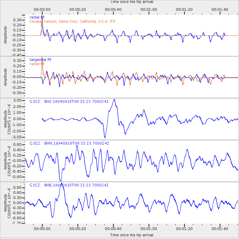
SCZ Chualar Canyon, Santa Cruz, California, U.S.A. - Earthquake Result Viewer

| Earthquake location: |
Taiwan Region |
| Earthquake latitude/longitude: |
22.5/118.7 |
| Earthquake time(UTC): |
1994/09/16 (259) 06:20:18 GMT |
| Earthquake Depth: |
12 km |
| Earthquake Magnitude: |
6.5 MB, 6.7 MS, 6.8 UNKNOWN, 6.7 MW |
| Earthquake Catalog/Contributor: |
WHDF/NEIC |
|
| Network: |
G GEOSCOPE |
| Station: |
SCZ Chualar Canyon, Santa Cruz, California, U.S.A. |
| Lat/Lon: |
36.60 N/121.40 W |
| Elevation: |
261 m |
|
| Distance: |
98.3 deg |
| Az: |
44.855 deg |
| Baz: |
305.88 deg |
| Ray Param: |
0.039949626 |
| Estimated Moho Depth: |
20.5 km |
| Estimated Crust Vp/Vs: |
1.85 |
| Assumed Crust Vp: |
6.391 km/s |
| Estimated Crust Vs: |
3.454 km/s |
| Estimated Crust Poisson's Ratio: |
0.29 |
|
| Radial Match: |
88.332146 % |
| Radial Bump: |
400 |
| Transverse Match: |
63.77105 % |
| Transverse Bump: |
400 |
| SOD ConfigId: |
17000 |
| Insert Time: |
2010-02-26 23:49:40.944 +0000 |
| GWidth: |
2.5 |
| Max Bumps: |
400 |
| Tol: |
0.001 |
|
Signal To Noise
| Channel | StoN | STA | LTA |
| G:SCZ: :BHN:19940916T06:33:23.700024Z | 1.6862645 | 2.2772394E-7 | 1.3504639E-7 |
| G:SCZ: :BHE:19940916T06:33:23.700024Z | 1.099283 | 1.3942544E-7 | 1.2683307E-7 |
| G:SCZ: :BHZ:19940916T06:33:23.700024Z | 4.5869784 | 6.060627E-7 | 1.3212677E-7 |
| Arrivals |
| Ps | 2.8 SECOND |
| PpPs | 9.0 SECOND |
| PsPs/PpSs | 12 SECOND |


