You are here: Home > Network List > UW - Pacific Northwest Regional Seismic Network Stations List
> Station UMAT Pilot Rock, OR, USA > Earthquake Result Viewer
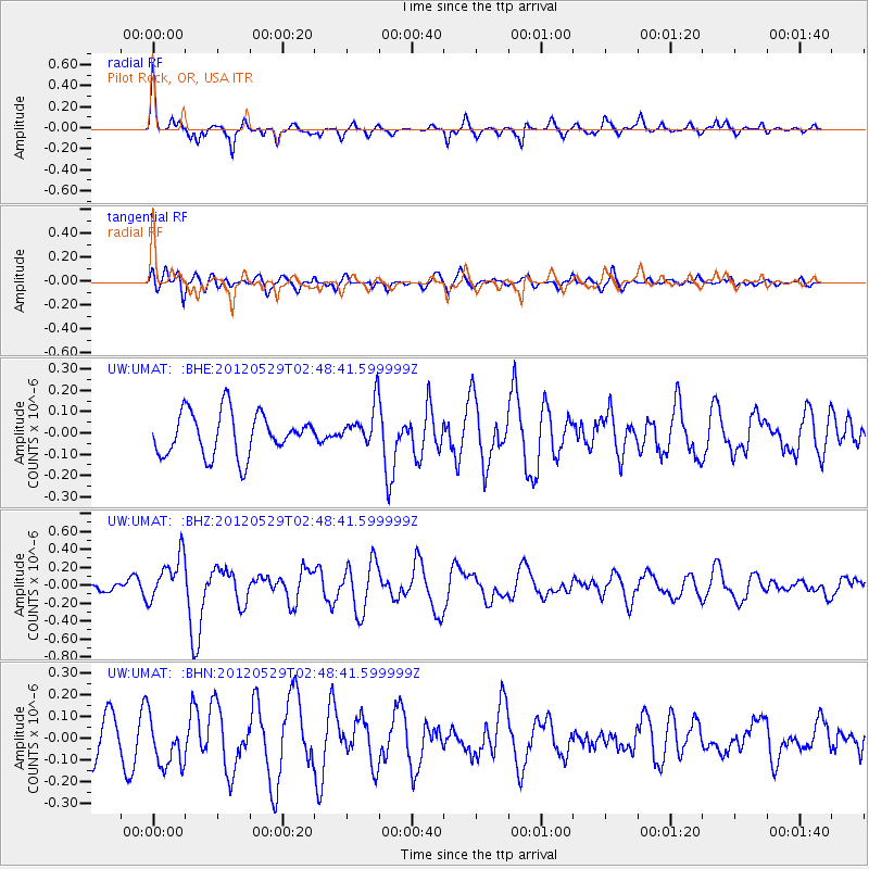
UMAT Pilot Rock, OR, USA - Earthquake Result Viewer
*The percent match for this event was below the threshold and hence no stack was calculated.
| Earthquake location: |
Komandorskiye Ostrova Region |
| Earthquake latitude/longitude: |
54.4/168.9 |
| Earthquake time(UTC): |
2012/05/29 (150) 02:40:53 GMT |
| Earthquake Depth: |
10 km |
| Earthquake Magnitude: |
5.5 MS, 5.4 MB, 5.6 MW, 5.6 MW |
| Earthquake Catalog/Contributor: |
WHDF/NEIC |
|
| Network: |
UW Pacific Northwest Regional Seismic Network |
| Station: |
UMAT Pilot Rock, OR, USA |
| Lat/Lon: |
45.29 N/118.96 W |
| Elevation: |
1318 m |
|
| Distance: |
45.5 deg |
| Az: |
70.44 deg |
| Baz: |
308.637 deg |
| Ray Param: |
$rayparam |
*The percent match for this event was below the threshold and hence was not used in the summary stack. |
|
| Radial Match: |
71.8388 % |
| Radial Bump: |
343 |
| Transverse Match: |
51.034218 % |
| Transverse Bump: |
400 |
| SOD ConfigId: |
455246 |
| Insert Time: |
2012-09-25 01:42:57.378 +0000 |
| GWidth: |
2.5 |
| Max Bumps: |
400 |
| Tol: |
0.001 |
|
Signal To Noise
| Channel | StoN | STA | LTA |
| UW:UMAT: :BHZ:20120529T02:48:41.599999Z | 2.5850513 | 2.5320577E-7 | 9.795E-8 |
| UW:UMAT: :BHN:20120529T02:48:41.599999Z | 1.6276023 | 1.1211264E-7 | 6.888208E-8 |
| UW:UMAT: :BHE:20120529T02:48:41.599999Z | 0.9606106 | 9.610303E-8 | 1.00043685E-7 |
| Arrivals |
| Ps | |
| PpPs | |
| PsPs/PpSs | |


