You are here: Home > Network List > GS - US Geological Survey Networks Stations List
> Station KAN12 Houston Home > Earthquake Result Viewer
KAN12 Houston Home - Earthquake Result Viewer
| Earthquake location: |
Leeward Islands |
| Earthquake latitude/longitude: |
17.1/-60.4 |
| Earthquake time(UTC): |
2014/05/16 (136) 11:01:42 GMT |
| Earthquake Depth: |
24 km |
| Earthquake Magnitude: |
6.0 MWP, 6.0 MI |
| Earthquake Catalog/Contributor: |
NEIC PDE/NEIC COMCAT |
|
| Network: |
GS US Geological Survey Networks |
| Station: |
KAN12 Houston Home |
| Lat/Lon: |
37.30 N/98.00 W |
| Elevation: |
426 m |
|
| Distance: |
38.7 deg |
| Az: |
308.894 deg |
| Baz: |
111.021 deg |
| Ray Param: |
0.075370684 |
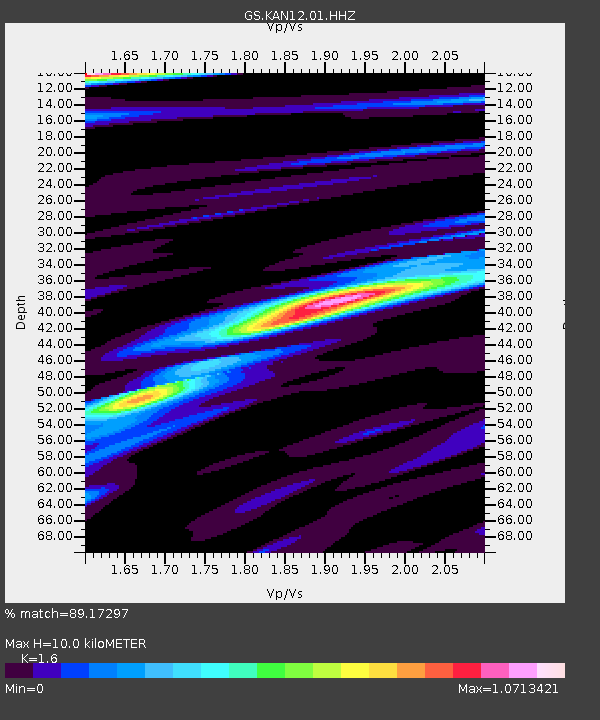
| Estimated Moho Depth: |
10.0 km |
| Estimated Crust Vp/Vs: |
1.60 |
| Assumed Crust Vp: |
6.483 km/s |
| Estimated Crust Vs: |
4.052 km/s |
| Estimated Crust Poisson's Ratio: |
0.18 |
|
| Radial Match: |
89.17297 % |
| Radial Bump: |
323 |
| Transverse Match: |
68.613014 % |
| Transverse Bump: |
400 |
| SOD ConfigId: |
3390531 |
| Insert Time: |
2019-04-11 21:59:52.152 +0000 |
| GWidth: |
2.5 |
| Max Bumps: |
400 |
| Tol: |
0.001 |
|

Signal To Noise
| Channel | StoN | STA | LTA |
| GS:KAN12:01:HHZ:20140516T11:08:34.489999Z | 8.332687 | 9.59906E-7 | 1.1519765E-7 |
| GS:KAN12:01:HHN:20140516T11:08:34.489999Z | 1.1923628 | 2.1876127E-7 | 1.8346871E-7 |
| GS:KAN12:01:HHE:20140516T11:08:34.489999Z | 1.436321 | 3.108478E-7 | 2.1641947E-7 |
| Arrivals |
| Ps | 1.0 SECOND |
| PpPs | 3.7 SECOND |
| PsPs/PpSs | 4.7 SECOND |


