You are here: Home > Network List > TA - USArray Transportable Network (new EarthScope stations) Stations List
> Station E62A Clayton Lake, ME, USA > Earthquake Result Viewer
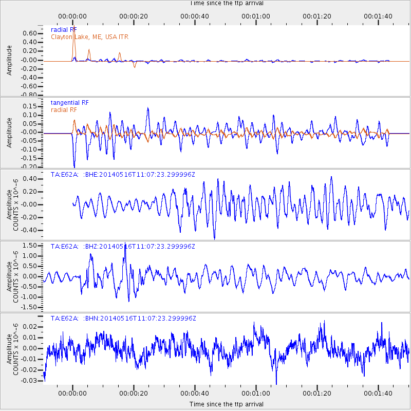
E62A Clayton Lake, ME, USA - Earthquake Result Viewer
*The percent match for this event was below the threshold and hence no stack was calculated.
| Earthquake location: |
Leeward Islands |
| Earthquake latitude/longitude: |
17.1/-60.4 |
| Earthquake time(UTC): |
2014/05/16 (136) 11:01:42 GMT |
| Earthquake Depth: |
24 km |
| Earthquake Magnitude: |
6.0 MWP, 6.0 MI |
| Earthquake Catalog/Contributor: |
NEIC PDE/NEIC COMCAT |
|
| Network: |
TA USArray Transportable Network (new EarthScope stations) |
| Station: |
E62A Clayton Lake, ME, USA |
| Lat/Lon: |
46.62 N/69.52 W |
| Elevation: |
356 m |
|
| Distance: |
30.4 deg |
| Az: |
347.518 deg |
| Baz: |
162.548 deg |
| Ray Param: |
$rayparam |
*The percent match for this event was below the threshold and hence was not used in the summary stack. |
|
| Radial Match: |
75.83059 % |
| Radial Bump: |
400 |
| Transverse Match: |
75.52347 % |
| Transverse Bump: |
400 |
| SOD ConfigId: |
3390531 |
| Insert Time: |
2019-04-11 22:01:39.675 +0000 |
| GWidth: |
2.5 |
| Max Bumps: |
400 |
| Tol: |
0.001 |
|
Signal To Noise
| Channel | StoN | STA | LTA |
| TA:E62A: :BHZ:20140516T11:07:23.299996Z | 2.53847 | 2.8100138E-7 | 1.1069714E-7 |
| TA:E62A: :BHN:20140516T11:07:23.299996Z | 0.80457675 | 6.5626544E-9 | 8.156654E-9 |
| TA:E62A: :BHE:20140516T11:07:23.299996Z | 1.6380614 | 1.4146593E-7 | 8.63618E-8 |
| Arrivals |
| Ps | |
| PpPs | |
| PsPs/PpSs | |


