You are here: Home > Network List > TA - USArray Transportable Network (new EarthScope stations) Stations List
> Station G05D Wamic, OR, USA > Earthquake Result Viewer
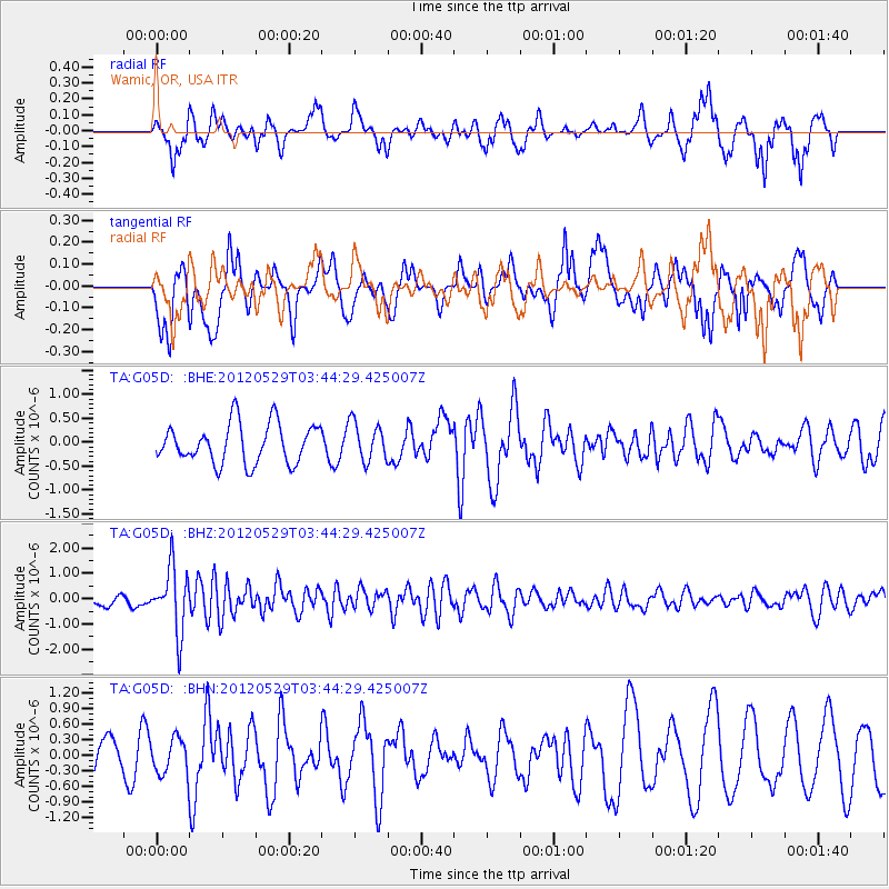
G05D Wamic, OR, USA - Earthquake Result Viewer
*The percent match for this event was below the threshold and hence no stack was calculated.
| Earthquake location: |
South Of Fiji Islands |
| Earthquake latitude/longitude: |
-22.1/-179.6 |
| Earthquake time(UTC): |
2012/05/29 (150) 03:33:25 GMT |
| Earthquake Depth: |
602 km |
| Earthquake Magnitude: |
5.6 MB, 5.8 MW, 5.9 MW |
| Earthquake Catalog/Contributor: |
WHDF/NEIC |
|
| Network: |
TA USArray Transportable Network (new EarthScope stations) |
| Station: |
G05D Wamic, OR, USA |
| Lat/Lon: |
45.24 N/121.32 W |
| Elevation: |
592 m |
|
| Distance: |
85.5 deg |
| Az: |
37.081 deg |
| Baz: |
232.308 deg |
| Ray Param: |
$rayparam |
*The percent match for this event was below the threshold and hence was not used in the summary stack. |
|
| Radial Match: |
55.731014 % |
| Radial Bump: |
351 |
| Transverse Match: |
65.7363 % |
| Transverse Bump: |
400 |
| SOD ConfigId: |
455246 |
| Insert Time: |
2012-09-25 02:03:21.965 +0000 |
| GWidth: |
2.5 |
| Max Bumps: |
400 |
| Tol: |
0.001 |
|
Signal To Noise
| Channel | StoN | STA | LTA |
| TA:G05D: :BHZ:20120529T03:44:29.425007Z | 5.169802 | 1.2638499E-6 | 2.444677E-7 |
| TA:G05D: :BHN:20120529T03:44:29.425007Z | 0.7746945 | 3.3862372E-7 | 4.3710614E-7 |
| TA:G05D: :BHE:20120529T03:44:29.425007Z | 0.97822857 | 4.027838E-7 | 4.1174815E-7 |
| Arrivals |
| Ps | |
| PpPs | |
| PsPs/PpSs | |


