You are here: Home > Network List > TA - USArray Transportable Network (new EarthScope stations) Stations List
> Station I55A Frankford, ON, CAN > Earthquake Result Viewer
I55A Frankford, ON, CAN - Earthquake Result Viewer
| Earthquake location: |
Leeward Islands |
| Earthquake latitude/longitude: |
17.1/-60.4 |
| Earthquake time(UTC): |
2014/05/16 (136) 11:01:42 GMT |
| Earthquake Depth: |
24 km |
| Earthquake Magnitude: |
6.0 MWP, 6.0 MI |
| Earthquake Catalog/Contributor: |
NEIC PDE/NEIC COMCAT |
|
| Network: |
TA USArray Transportable Network (new EarthScope stations) |
| Station: |
I55A Frankford, ON, CAN |
| Lat/Lon: |
44.22 N/77.68 W |
| Elevation: |
132 m |
|
| Distance: |
30.7 deg |
| Az: |
335.276 deg |
| Baz: |
146.199 deg |
| Ray Param: |
0.07923609 |
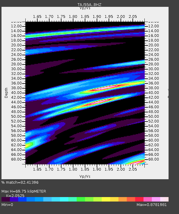
| Estimated Moho Depth: |
69.75 km |
| Estimated Crust Vp/Vs: |
2.05 |
| Assumed Crust Vp: |
6.577 km/s |
| Estimated Crust Vs: |
3.204 km/s |
| Estimated Crust Poisson's Ratio: |
0.34 |
|
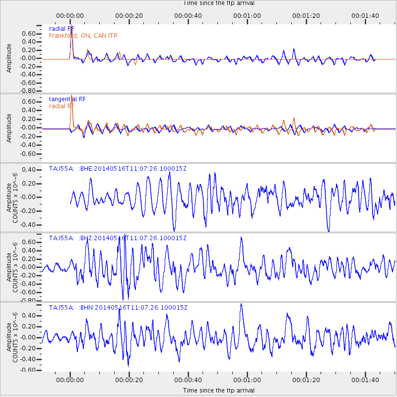
| Radial Match: |
82.41396 % |
| Radial Bump: |
302 |
| Transverse Match: |
51.796394 % |
| Transverse Bump: |
329 |
| SOD ConfigId: |
3390531 |
| Insert Time: |
2019-04-11 22:01:54.097 +0000 |
| GWidth: |
2.5 |
| Max Bumps: |
400 |
| Tol: |
0.001 |
|
Signal To Noise
| Channel | StoN | STA | LTA |
| TA:I55A: :BHZ:20140516T11:07:26.100015Z | 1.5385193 | 1.8089129E-7 | 1.17574935E-7 |
| TA:I55A: :BHN:20140516T11:07:26.100015Z | 1.3249544 | 9.875138E-8 | 7.4531904E-8 |
| TA:I55A: :BHE:20140516T11:07:26.100015Z | 2.083069 | 2.0036632E-7 | 9.618803E-8 |
| Arrivals |
| Ps | 12 SECOND |
| PpPs | 30 SECOND |
| PsPs/PpSs | 42 SECOND |


