You are here: Home > Network List > TA - USArray Transportable Network (new EarthScope stations) Stations List
> Station H04D Lebanon, OR, USA > Earthquake Result Viewer
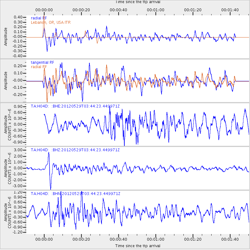
H04D Lebanon, OR, USA - Earthquake Result Viewer
*The percent match for this event was below the threshold and hence no stack was calculated.
| Earthquake location: |
South Of Fiji Islands |
| Earthquake latitude/longitude: |
-22.1/-179.6 |
| Earthquake time(UTC): |
2012/05/29 (150) 03:33:25 GMT |
| Earthquake Depth: |
602 km |
| Earthquake Magnitude: |
5.6 MB, 5.8 MW, 5.9 MW |
| Earthquake Catalog/Contributor: |
WHDF/NEIC |
|
| Network: |
TA USArray Transportable Network (new EarthScope stations) |
| Station: |
H04D Lebanon, OR, USA |
| Lat/Lon: |
44.52 N/122.74 W |
| Elevation: |
284 m |
|
| Distance: |
84.2 deg |
| Az: |
37.021 deg |
| Baz: |
231.303 deg |
| Ray Param: |
$rayparam |
*The percent match for this event was below the threshold and hence was not used in the summary stack. |
|
| Radial Match: |
66.84717 % |
| Radial Bump: |
400 |
| Transverse Match: |
66.62933 % |
| Transverse Bump: |
400 |
| SOD ConfigId: |
455246 |
| Insert Time: |
2012-09-25 02:04:38.261 +0000 |
| GWidth: |
2.5 |
| Max Bumps: |
400 |
| Tol: |
0.001 |
|
Signal To Noise
| Channel | StoN | STA | LTA |
| TA:H04D: :BHZ:20120529T03:44:23.449971Z | 5.9862514 | 1.4511193E-6 | 2.4240867E-7 |
| TA:H04D: :BHN:20120529T03:44:23.449971Z | 2.178527 | 3.772495E-7 | 1.7316724E-7 |
| TA:H04D: :BHE:20120529T03:44:23.449971Z | 1.2802662 | 2.782451E-7 | 2.1733379E-7 |
| Arrivals |
| Ps | |
| PpPs | |
| PsPs/PpSs | |


