You are here: Home > Network List > G - GEOSCOPE Stations List
> Station SCZ Chualar Canyon, Santa Cruz, California, U.S.A. > Earthquake Result Viewer
SCZ Chualar Canyon, Santa Cruz, California, U.S.A. - Earthquake Result Viewer
| Earthquake location: |
Rat Islands, Aleutian Islands |
| Earthquake latitude/longitude: |
51.3/179.7 |
| Earthquake time(UTC): |
1995/04/23 (113) 02:55:54 GMT |
| Earthquake Depth: |
16 km |
| Earthquake Magnitude: |
6.1 MB, 6.4 MS, 6.5 UNKNOWN, 6.7 ML |
| Earthquake Catalog/Contributor: |
WHDF/NEIC |
|
| Network: |
G GEOSCOPE |
| Station: |
SCZ Chualar Canyon, Santa Cruz, California, U.S.A. |
| Lat/Lon: |
36.60 N/121.40 W |
| Elevation: |
261 m |
|
| Distance: |
43.7 deg |
| Az: |
85.977 deg |
| Baz: |
308.966 deg |
| Ray Param: |
0.07237715 |
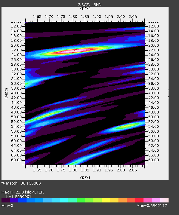
| Estimated Moho Depth: |
22.0 km |
| Estimated Crust Vp/Vs: |
1.81 |
| Assumed Crust Vp: |
6.391 km/s |
| Estimated Crust Vs: |
3.541 km/s |
| Estimated Crust Poisson's Ratio: |
0.28 |
|
| Radial Match: |
86.135086 % |
| Radial Bump: |
314 |
| Transverse Match: |
83.37961 % |
| Transverse Bump: |
400 |
| SOD ConfigId: |
6273 |
| Insert Time: |
2010-02-26 23:50:23.169 +0000 |
| GWidth: |
2.5 |
| Max Bumps: |
400 |
| Tol: |
0.001 |
|
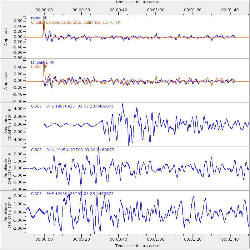
Signal To Noise
| Channel | StoN | STA | LTA |
| G:SCZ: :BHN:19950423T03:03:28.048987Z | 2.1620946 | 3.3056818E-7 | 1.5289257E-7 |
| G:SCZ: :BHE:19950423T03:03:28.048987Z | 2.0097454 | 4.6856468E-7 | 2.3314631E-7 |
| G:SCZ: :BHZ:19950423T03:03:28.048987Z | 3.807739 | 1.0939195E-6 | 2.8728846E-7 |
| Arrivals |
| Ps | 3.0 SECOND |
| PpPs | 9.1 SECOND |
| PsPs/PpSs | 12 SECOND |


