You are here: Home > Network List > X812 - Deep Structure of Three Continental Sutures in Eastern North America Stations List
> Station QM30 Fish River Lake, Maine, USA > Earthquake Result Viewer
QM30 Fish River Lake, Maine, USA - Earthquake Result Viewer
| Earthquake location: |
Leeward Islands |
| Earthquake latitude/longitude: |
17.1/-60.4 |
| Earthquake time(UTC): |
2014/05/16 (136) 11:01:42 GMT |
| Earthquake Depth: |
24 km |
| Earthquake Magnitude: |
6.0 MWP, 6.0 MI |
| Earthquake Catalog/Contributor: |
NEIC PDE/NEIC COMCAT |
|
| Network: |
X8 Deep Structure of Three Continental Sutures in Eastern North America |
| Station: |
QM30 Fish River Lake, Maine, USA |
| Lat/Lon: |
46.83 N/68.76 W |
| Elevation: |
262 m |
|
| Distance: |
30.5 deg |
| Az: |
348.628 deg |
| Baz: |
164.058 deg |
| Ray Param: |
0.07930696 |
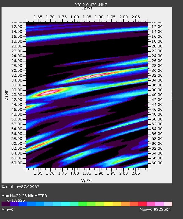
| Estimated Moho Depth: |
32.25 km |
| Estimated Crust Vp/Vs: |
1.86 |
| Assumed Crust Vp: |
6.419 km/s |
| Estimated Crust Vs: |
3.447 km/s |
| Estimated Crust Poisson's Ratio: |
0.30 |
|
| Radial Match: |
87.00057 % |
| Radial Bump: |
245 |
| Transverse Match: |
55.39064 % |
| Transverse Bump: |
349 |
| SOD ConfigId: |
3390531 |
| Insert Time: |
2019-04-11 22:02:44.725 +0000 |
| GWidth: |
2.5 |
| Max Bumps: |
400 |
| Tol: |
0.001 |
|

Signal To Noise
| Channel | StoN | STA | LTA |
| X8:QM30: :HHZ:20140516T11:07:23.759988Z | 3.0668821 | 2.3065665E-7 | 7.520884E-8 |
| X8:QM30: :HHN:20140516T11:07:23.759988Z | 3.2051249 | 2.023559E-7 | 6.313511E-8 |
| X8:QM30: :HHE:20140516T11:07:23.759988Z | 0.53368694 | 7.487167E-8 | 1.4029138E-7 |
| Arrivals |
| Ps | 4.7 SECOND |
| PpPs | 13 SECOND |
| PsPs/PpSs | 18 SECOND |


