You are here: Home > Network List > G - GEOSCOPE Stations List
> Station SCZ Chualar Canyon, Santa Cruz, California, U.S.A. > Earthquake Result Viewer
SCZ Chualar Canyon, Santa Cruz, California, U.S.A. - Earthquake Result Viewer
| Earthquake location: |
Sea Of Japan |
| Earthquake latitude/longitude: |
38.2/135.1 |
| Earthquake time(UTC): |
1995/03/31 (090) 14:01:40 GMT |
| Earthquake Depth: |
365 km |
| Earthquake Magnitude: |
6.0 MB, 6.2 UNKNOWN, 6.3 MW |
| Earthquake Catalog/Contributor: |
WHDF/NEIC |
|
| Network: |
G GEOSCOPE |
| Station: |
SCZ Chualar Canyon, Santa Cruz, California, U.S.A. |
| Lat/Lon: |
36.60 N/121.40 W |
| Elevation: |
261 m |
|
| Distance: |
77.5 deg |
| Az: |
53.266 deg |
| Baz: |
308.266 deg |
| Ray Param: |
0.04926115 |
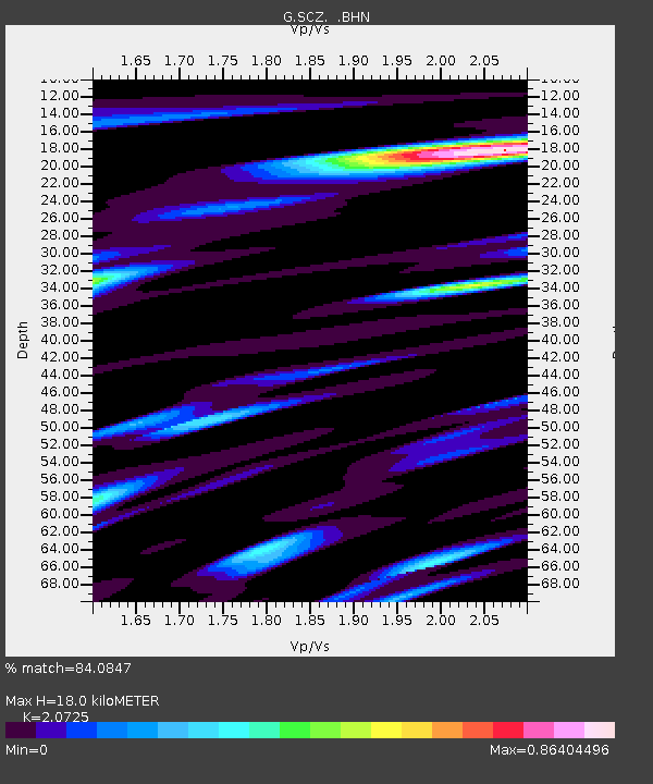
| Estimated Moho Depth: |
18.0 km |
| Estimated Crust Vp/Vs: |
2.07 |
| Assumed Crust Vp: |
6.391 km/s |
| Estimated Crust Vs: |
3.084 km/s |
| Estimated Crust Poisson's Ratio: |
0.35 |
|
| Radial Match: |
84.0847 % |
| Radial Bump: |
400 |
| Transverse Match: |
73.5399 % |
| Transverse Bump: |
400 |
| SOD ConfigId: |
6273 |
| Insert Time: |
2010-02-26 23:50:25.963 +0000 |
| GWidth: |
2.5 |
| Max Bumps: |
400 |
| Tol: |
0.001 |
|

Signal To Noise
| Channel | StoN | STA | LTA |
| G:SCZ: :BHN:19950331T14:12:25.898999Z | 5.967649 | 5.076129E-7 | 8.506079E-8 |
| G:SCZ: :BHE:19950331T14:12:25.898999Z | 3.4911995 | 5.125531E-7 | 1.468129E-7 |
| G:SCZ: :BHZ:19950331T14:12:25.898999Z | 8.626703 | 1.8811629E-6 | 2.180628E-7 |
| Arrivals |
| Ps | 3.1 SECOND |
| PpPs | 8.4 SECOND |
| PsPs/PpSs | 12 SECOND |


