You are here: Home > Network List > X812 - Deep Structure of Three Continental Sutures in Eastern North America Stations List
> Station QM80 Route du Nord, Quebec, Canada > Earthquake Result Viewer
QM80 Route du Nord, Quebec, Canada - Earthquake Result Viewer
| Earthquake location: |
Leeward Islands |
| Earthquake latitude/longitude: |
17.1/-60.4 |
| Earthquake time(UTC): |
2014/05/16 (136) 11:01:42 GMT |
| Earthquake Depth: |
24 km |
| Earthquake Magnitude: |
6.0 MWP, 6.0 MI |
| Earthquake Catalog/Contributor: |
NEIC PDE/NEIC COMCAT |
|
| Network: |
X8 Deep Structure of Three Continental Sutures in Eastern North America |
| Station: |
QM80 Route du Nord, Quebec, Canada |
| Lat/Lon: |
50.96 N/75.23 W |
| Elevation: |
371 m |
|
| Distance: |
35.8 deg |
| Az: |
343.939 deg |
| Baz: |
155.264 deg |
| Ray Param: |
0.076979026 |
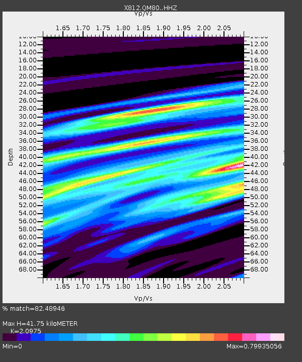
| Estimated Moho Depth: |
41.75 km |
| Estimated Crust Vp/Vs: |
2.10 |
| Assumed Crust Vp: |
6.61 km/s |
| Estimated Crust Vs: |
3.151 km/s |
| Estimated Crust Poisson's Ratio: |
0.35 |
|
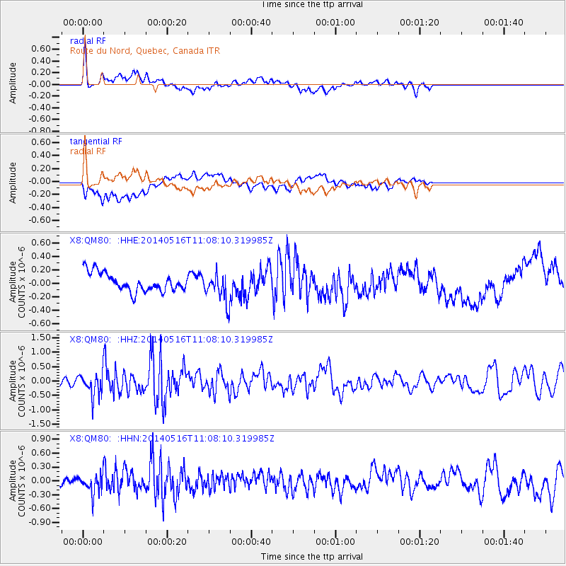
| Radial Match: |
82.48946 % |
| Radial Bump: |
400 |
| Transverse Match: |
57.988785 % |
| Transverse Bump: |
400 |
| SOD ConfigId: |
3390531 |
| Insert Time: |
2019-04-11 22:02:55.785 +0000 |
| GWidth: |
2.5 |
| Max Bumps: |
400 |
| Tol: |
0.001 |
|
Signal To Noise
| Channel | StoN | STA | LTA |
| X8:QM80: :HHZ:20140516T11:08:10.319985Z | 3.4036136 | 3.9312786E-7 | 1.1550309E-7 |
| X8:QM80: :HHN:20140516T11:08:10.319985Z | 2.566771 | 2.0667383E-7 | 8.0519E-8 |
| X8:QM80: :HHE:20140516T11:08:10.319985Z | 1.1054846 | 1.533149E-7 | 1.386857E-7 |
| Arrivals |
| Ps | 7.4 SECOND |
| PpPs | 18 SECOND |
| PsPs/PpSs | 26 SECOND |


