You are here: Home > Network List > G - GEOSCOPE Stations List
> Station SCZ Chualar Canyon, Santa Cruz, California, U.S.A. > Earthquake Result Viewer
SCZ Chualar Canyon, Santa Cruz, California, U.S.A. - Earthquake Result Viewer
| Earthquake location: |
Near East Coast Of Honshu, Japan |
| Earthquake latitude/longitude: |
40.2/142.2 |
| Earthquake time(UTC): |
1995/01/06 (006) 22:37:37 GMT |
| Earthquake Depth: |
57 km |
| Earthquake Magnitude: |
6.7 MB, 6.6 UNKNOWN, 7.0 MW |
| Earthquake Catalog/Contributor: |
WHDF/NEIC |
|
| Network: |
G GEOSCOPE |
| Station: |
SCZ Chualar Canyon, Santa Cruz, California, U.S.A. |
| Lat/Lon: |
36.60 N/121.40 W |
| Elevation: |
261 m |
|
| Distance: |
71.7 deg |
| Az: |
57.385 deg |
| Baz: |
306.74 deg |
| Ray Param: |
0.0540211 |
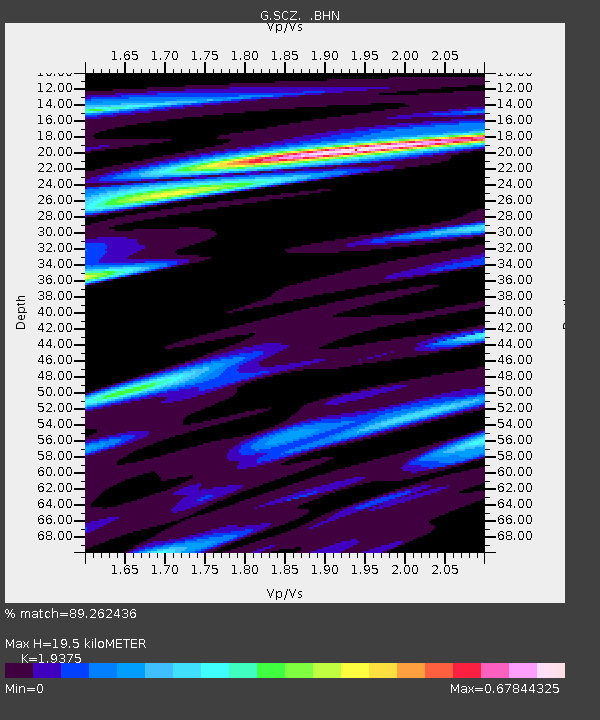
| Estimated Moho Depth: |
19.5 km |
| Estimated Crust Vp/Vs: |
1.94 |
| Assumed Crust Vp: |
6.391 km/s |
| Estimated Crust Vs: |
3.298 km/s |
| Estimated Crust Poisson's Ratio: |
0.32 |
|
| Radial Match: |
89.262436 % |
| Radial Bump: |
400 |
| Transverse Match: |
70.72186 % |
| Transverse Bump: |
400 |
| SOD ConfigId: |
6273 |
| Insert Time: |
2010-02-26 23:50:34.189 +0000 |
| GWidth: |
2.5 |
| Max Bumps: |
400 |
| Tol: |
0.001 |
|

Signal To Noise
| Channel | StoN | STA | LTA |
| G:SCZ: :BHN:19950106T22:48:23.050024Z | 1.716652 | 6.628859E-7 | 3.8615042E-7 |
| G:SCZ: :BHE:19950106T22:48:23.050024Z | 2.01727 | 9.611829E-7 | 4.7647703E-7 |
| G:SCZ: :BHZ:19950106T22:48:23.050024Z | 5.793305 | 2.1709895E-6 | 3.7474112E-7 |
| Arrivals |
| Ps | 3.0 SECOND |
| PpPs | 8.7 SECOND |
| PsPs/PpSs | 12 SECOND |


