You are here: Home > Network List > G - GEOSCOPE Stations List
> Station SCZ Chualar Canyon, Santa Cruz, California, U.S.A. > Earthquake Result Viewer
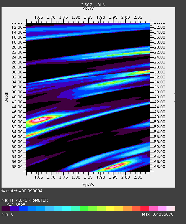
SCZ Chualar Canyon, Santa Cruz, California, U.S.A. - Earthquake Result Viewer
| Earthquake location: |
Off E. Coast Of N. Island, N.Z. |
| Earthquake latitude/longitude: |
-37.7/178.8 |
| Earthquake time(UTC): |
1995/02/05 (036) 22:51:10 GMT |
| Earthquake Depth: |
59 km |
| Earthquake Magnitude: |
6.4 MB, 7.1 UNKNOWN, 7.1 MW |
| Earthquake Catalog/Contributor: |
WHDF/NEIC |
|
| Network: |
G GEOSCOPE |
| Station: |
SCZ Chualar Canyon, Santa Cruz, California, U.S.A. |
| Lat/Lon: |
36.60 N/121.40 W |
| Elevation: |
261 m |
|
| Distance: |
92.3 deg |
| Az: |
44.131 deg |
| Baz: |
223.329 deg |
| Ray Param: |
0.041450497 |
| Estimated Moho Depth: |
48.75 km |
| Estimated Crust Vp/Vs: |
1.65 |
| Assumed Crust Vp: |
6.391 km/s |
| Estimated Crust Vs: |
3.867 km/s |
| Estimated Crust Poisson's Ratio: |
0.21 |
|
| Radial Match: |
90.993004 % |
| Radial Bump: |
400 |
| Transverse Match: |
75.933075 % |
| Transverse Bump: |
400 |
| SOD ConfigId: |
6273 |
| Insert Time: |
2010-02-26 23:50:35.581 +0000 |
| GWidth: |
2.5 |
| Max Bumps: |
400 |
| Tol: |
0.001 |
|

Signal To Noise
| Channel | StoN | STA | LTA |
| G:SCZ: :BHN:19950205T23:03:43.050024Z | 4.7030473 | 1.5157099E-6 | 3.2228252E-7 |
| G:SCZ: :BHE:19950205T23:03:43.050024Z | 5.208733 | 1.3589698E-6 | 2.6090217E-7 |
| G:SCZ: :BHZ:19950205T23:03:43.050024Z | 21.185263 | 6.1741994E-6 | 2.9143843E-7 |
| Arrivals |
| Ps | 5.1 SECOND |
| PpPs | 20 SECOND |
| PsPs/PpSs | 25 SECOND |


