You are here: Home > Network List > NE - New England Seismic Network Stations List
> Station FFD Franklin Falls Dam, NH > Earthquake Result Viewer
FFD Franklin Falls Dam, NH - Earthquake Result Viewer
| Earthquake location: |
Northern Italy |
| Earthquake latitude/longitude: |
44.9/11.1 |
| Earthquake time(UTC): |
2012/05/29 (150) 07:00:03 GMT |
| Earthquake Depth: |
10 km |
| Earthquake Magnitude: |
5.9 MB, 5.8 MS, 5.8 MW, 5.8 MW |
| Earthquake Catalog/Contributor: |
WHDF/NEIC |
|
| Network: |
NE New England Seismic Network |
| Station: |
FFD Franklin Falls Dam, NH |
| Lat/Lon: |
43.47 N/71.65 W |
| Elevation: |
131 m |
|
| Distance: |
56.8 deg |
| Az: |
300.356 deg |
| Baz: |
57.467 deg |
| Ray Param: |
0.06389228 |
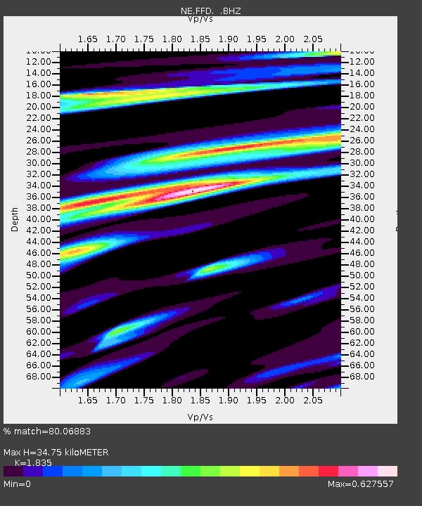
| Estimated Moho Depth: |
34.75 km |
| Estimated Crust Vp/Vs: |
1.84 |
| Assumed Crust Vp: |
6.419 km/s |
| Estimated Crust Vs: |
3.498 km/s |
| Estimated Crust Poisson's Ratio: |
0.29 |
|
| Radial Match: |
80.06883 % |
| Radial Bump: |
400 |
| Transverse Match: |
68.39525 % |
| Transverse Bump: |
400 |
| SOD ConfigId: |
455246 |
| Insert Time: |
2012-09-25 02:20:09.095 +0000 |
| GWidth: |
2.5 |
| Max Bumps: |
400 |
| Tol: |
0.001 |
|

Signal To Noise
| Channel | StoN | STA | LTA |
| NE:FFD: :BHZ:20120529T07:09:16.349976Z | 4.4663143 | 5.706153E-7 | 1.2775978E-7 |
| NE:FFD: :BHN:20120529T07:09:16.349976Z | 1.6895926 | 2.0535408E-7 | 1.215406E-7 |
| NE:FFD: :BHE:20120529T07:09:16.349976Z | 2.4879608 | 2.6883444E-7 | 1.0805413E-7 |
| Arrivals |
| Ps | 4.7 SECOND |
| PpPs | 15 SECOND |
| PsPs/PpSs | 19 SECOND |


