You are here: Home > Network List > TA - USArray Transportable Network (new EarthScope stations) Stations List
> Station G36A St. Michael, MN, USA > Earthquake Result Viewer
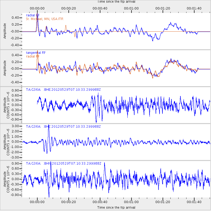
G36A St. Michael, MN, USA - Earthquake Result Viewer
*The percent match for this event was below the threshold and hence no stack was calculated.
| Earthquake location: |
Northern Italy |
| Earthquake latitude/longitude: |
44.9/11.1 |
| Earthquake time(UTC): |
2012/05/29 (150) 07:00:03 GMT |
| Earthquake Depth: |
10 km |
| Earthquake Magnitude: |
5.9 MB, 5.8 MS, 5.8 MW, 5.8 MW |
| Earthquake Catalog/Contributor: |
WHDF/NEIC |
|
| Network: |
TA USArray Transportable Network (new EarthScope stations) |
| Station: |
G36A St. Michael, MN, USA |
| Lat/Lon: |
45.23 N/93.75 W |
| Elevation: |
293 m |
|
| Distance: |
68.4 deg |
| Az: |
312.711 deg |
| Baz: |
47.706 deg |
| Ray Param: |
$rayparam |
*The percent match for this event was below the threshold and hence was not used in the summary stack. |
|
| Radial Match: |
62.68638 % |
| Radial Bump: |
400 |
| Transverse Match: |
51.96052 % |
| Transverse Bump: |
400 |
| SOD ConfigId: |
455246 |
| Insert Time: |
2012-09-25 02:27:23.989 +0000 |
| GWidth: |
2.5 |
| Max Bumps: |
400 |
| Tol: |
0.001 |
|
Signal To Noise
| Channel | StoN | STA | LTA |
| TA:G36A: :BHZ:20120529T07:10:33.299988Z | 6.669541 | 5.735041E-7 | 8.598854E-8 |
| TA:G36A: :BHN:20120529T07:10:33.299988Z | 1.1495116 | 1.9212256E-7 | 1.6713408E-7 |
| TA:G36A: :BHE:20120529T07:10:33.299988Z | 1.1602035 | 2.2942984E-7 | 1.9774967E-7 |
| Arrivals |
| Ps | |
| PpPs | |
| PsPs/PpSs | |


