You are here: Home > Network List > G - GEOSCOPE Stations List
> Station SCZ Chualar Canyon, Santa Cruz, California, U.S.A. > Earthquake Result Viewer
SCZ Chualar Canyon, Santa Cruz, California, U.S.A. - Earthquake Result Viewer

| Earthquake location: |
Mariana Islands |
| Earthquake latitude/longitude: |
18.9/145.2 |
| Earthquake time(UTC): |
1995/08/23 (235) 07:06:02 GMT |
| Earthquake Depth: |
596 km |
| Earthquake Magnitude: |
6.3 MB, 6.3 UNKNOWN, 7.0 MW |
| Earthquake Catalog/Contributor: |
WHDF/NEIC |
|
| Network: |
G GEOSCOPE |
| Station: |
SCZ Chualar Canyon, Santa Cruz, California, U.S.A. |
| Lat/Lon: |
36.60 N/121.40 W |
| Elevation: |
261 m |
|
| Distance: |
81.6 deg |
| Az: |
54.287 deg |
| Baz: |
287.165 deg |
| Ray Param: |
0.045636423 |
| Estimated Moho Depth: |
47.0 km |
| Estimated Crust Vp/Vs: |
1.79 |
| Assumed Crust Vp: |
6.391 km/s |
| Estimated Crust Vs: |
3.575 km/s |
| Estimated Crust Poisson's Ratio: |
0.27 |
|
| Radial Match: |
89.50962 % |
| Radial Bump: |
400 |
| Transverse Match: |
87.51429 % |
| Transverse Bump: |
400 |
| SOD ConfigId: |
6273 |
| Insert Time: |
2010-02-26 23:50:50.442 +0000 |
| GWidth: |
2.5 |
| Max Bumps: |
400 |
| Tol: |
0.001 |
|
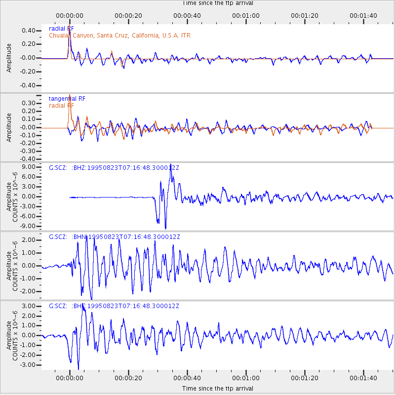
Signal To Noise
| Channel | StoN | STA | LTA |
| G:SCZ: :BHN:19950823T07:16:48.300012Z | 13.784635 | 9.452197E-7 | 6.857053E-8 |
| G:SCZ: :BHE:19950823T07:16:48.300012Z | 18.02633 | 1.8092555E-6 | 1.0036737E-7 |
| G:SCZ: :BHZ:19950823T07:16:48.300012Z | 88.094284 | 5.349594E-6 | 6.072578E-8 |
| Arrivals |
| Ps | 5.9 SECOND |
| PpPs | 20 SECOND |
| PsPs/PpSs | 26 SECOND |


