You are here: Home > Network List > TA - USArray Transportable Network (new EarthScope stations) Stations List
> Station E36A McGregor, MN, USA > Earthquake Result Viewer
E36A McGregor, MN, USA - Earthquake Result Viewer
| Earthquake location: |
Northern Italy |
| Earthquake latitude/longitude: |
44.9/11.1 |
| Earthquake time(UTC): |
2012/05/29 (150) 07:00:03 GMT |
| Earthquake Depth: |
10 km |
| Earthquake Magnitude: |
5.9 MB, 5.8 MS, 5.8 MW, 5.8 MW |
| Earthquake Catalog/Contributor: |
WHDF/NEIC |
|
| Network: |
TA USArray Transportable Network (new EarthScope stations) |
| Station: |
E36A McGregor, MN, USA |
| Lat/Lon: |
46.52 N/93.26 W |
| Elevation: |
393 m |
|
| Distance: |
67.3 deg |
| Az: |
313.491 deg |
| Baz: |
48.355 deg |
| Ray Param: |
0.05707825 |
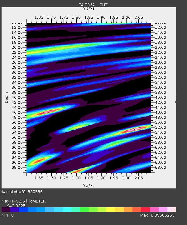
| Estimated Moho Depth: |
52.5 km |
| Estimated Crust Vp/Vs: |
2.03 |
| Assumed Crust Vp: |
6.571 km/s |
| Estimated Crust Vs: |
3.233 km/s |
| Estimated Crust Poisson's Ratio: |
0.34 |
|
| Radial Match: |
81.530556 % |
| Radial Bump: |
337 |
| Transverse Match: |
75.494354 % |
| Transverse Bump: |
400 |
| SOD ConfigId: |
455246 |
| Insert Time: |
2012-09-25 02:29:15.901 +0000 |
| GWidth: |
2.5 |
| Max Bumps: |
400 |
| Tol: |
0.001 |
|
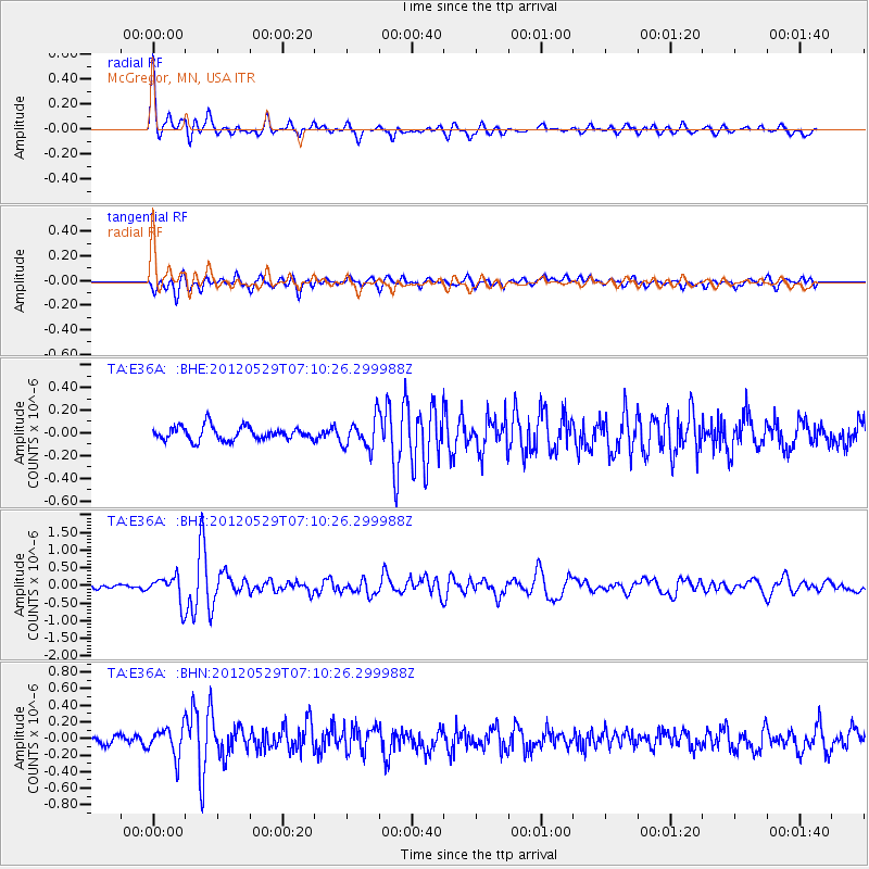
Signal To Noise
| Channel | StoN | STA | LTA |
| TA:E36A: :BHZ:20120529T07:10:26.299988Z | 5.0277815 | 3.7855094E-7 | 7.5291844E-8 |
| TA:E36A: :BHN:20120529T07:10:26.299988Z | 2.5234706 | 1.7564442E-7 | 6.96043E-8 |
| TA:E36A: :BHE:20120529T07:10:26.299988Z | 2.1734834 | 1.3013232E-7 | 5.9872704E-8 |
| Arrivals |
| Ps | 8.6 SECOND |
| PpPs | 23 SECOND |
| PsPs/PpSs | 32 SECOND |


