You are here: Home > Network List > G - GEOSCOPE Stations List
> Station SCZ Chualar Canyon, Santa Cruz, California, U.S.A. > Earthquake Result Viewer
SCZ Chualar Canyon, Santa Cruz, California, U.S.A. - Earthquake Result Viewer
| Earthquake location: |
Near N. Coast Of Eastern Siberia |
| Earthquake latitude/longitude: |
67.0/-173.2 |
| Earthquake time(UTC): |
1996/10/24 (298) 19:31:53 GMT |
| Earthquake Depth: |
20 km |
| Earthquake Magnitude: |
6.0 MB, 5.9 MS, 6.1 UNKNOWN, 5.8 ME |
| Earthquake Catalog/Contributor: |
WHDF/NEIC |
|
| Network: |
G GEOSCOPE |
| Station: |
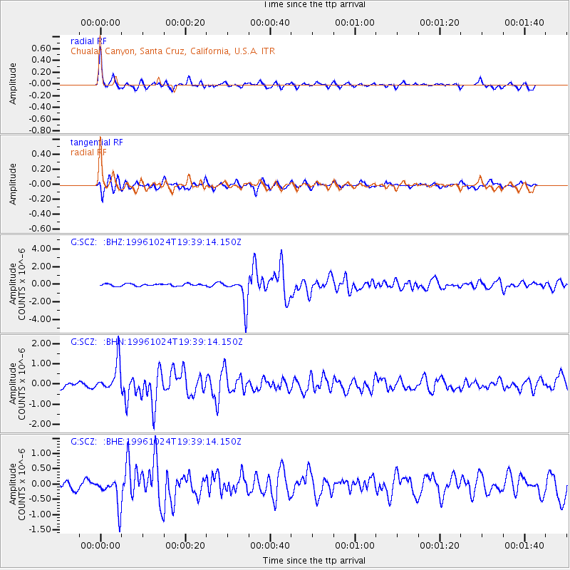
SCZ Chualar Canyon, Santa Cruz, California, U.S.A. |
| Lat/Lon: |
36.60 N/121.40 W |
| Elevation: |
261 m |
|
| Distance: |
42.2 deg |
| Az: |
109.491 deg |
| Baz: |
332.575 deg |
| Ray Param: |
0.07331463 |
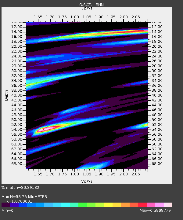
| Estimated Moho Depth: |
53.75 km |
| Estimated Crust Vp/Vs: |
1.67 |
| Assumed Crust Vp: |
6.391 km/s |
| Estimated Crust Vs: |
3.827 km/s |
| Estimated Crust Poisson's Ratio: |
0.22 |
|
| Radial Match: |
86.39182 % |
| Radial Bump: |
376 |
| Transverse Match: |
69.03041 % |
| Transverse Bump: |
400 |
| SOD ConfigId: |
6273 |
| Insert Time: |
2010-02-26 23:50:53.540 +0000 |
| GWidth: |
2.5 |
| Max Bumps: |
400 |
| Tol: |
0.001 |
|
Signal To Noise
| Channel | StoN | STA | LTA |
| G:SCZ: :BHN:19961024T19:39:14.150Z | 9.549313 | 7.6878865E-7 | 8.050723E-8 |
| G:SCZ: :BHE:19961024T19:39:14.150Z | 2.4215279 | 4.893065E-7 | 2.020652E-7 |
| G:SCZ: :BHZ:19961024T19:39:14.150Z | 13.534185 | 1.7087773E-6 | 1.2625638E-7 |
| Arrivals |
| Ps | 6.1 SECOND |
| PpPs | 21 SECOND |
| PsPs/PpSs | 27 SECOND |


