You are here: Home > Network List > TA - USArray Transportable Network (new EarthScope stations) Stations List
> Station N39A Derby Farms, Drakesville, IA, USA > Earthquake Result Viewer
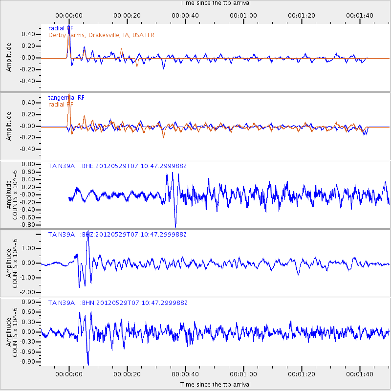
N39A Derby Farms, Drakesville, IA, USA - Earthquake Result Viewer

| Earthquake location: |
Northern Italy |
| Earthquake latitude/longitude: |
44.9/11.1 |
| Earthquake time(UTC): |
2012/05/29 (150) 07:00:03 GMT |
| Earthquake Depth: |
10 km |
| Earthquake Magnitude: |
5.9 MB, 5.8 MS, 5.8 MW, 5.8 MW |
| Earthquake Catalog/Contributor: |
WHDF/NEIC |
|
| Network: |
TA USArray Transportable Network (new EarthScope stations) |
| Station: |
N39A Derby Farms, Drakesville, IA, USA |
| Lat/Lon: |
40.88 N/92.50 W |
| Elevation: |
260 m |
|
| Distance: |
70.6 deg |
| Az: |
308.627 deg |
| Baz: |
47.125 deg |
| Ray Param: |
0.054848846 |
| Estimated Moho Depth: |
56.25 km |
| Estimated Crust Vp/Vs: |
1.92 |
| Assumed Crust Vp: |
6.498 km/s |
| Estimated Crust Vs: |
3.389 km/s |
| Estimated Crust Poisson's Ratio: |
0.31 |
|
| Radial Match: |
88.05868 % |
| Radial Bump: |
363 |
| Transverse Match: |
55.805374 % |
| Transverse Bump: |
400 |
| SOD ConfigId: |
455246 |
| Insert Time: |
2012-09-25 02:30:56.584 +0000 |
| GWidth: |
2.5 |
| Max Bumps: |
400 |
| Tol: |
0.001 |
|
Signal To Noise
| Channel | StoN | STA | LTA |
| TA:N39A: :BHZ:20120529T07:10:47.299988Z | 5.5747585 | 5.331758E-7 | 9.5641056E-8 |
| TA:N39A: :BHN:20120529T07:10:47.299988Z | 2.0995748 | 1.8916027E-7 | 9.009456E-8 |
| TA:N39A: :BHE:20120529T07:10:47.299988Z | 2.359484 | 1.8813482E-7 | 7.9735585E-8 |
| Arrivals |
| Ps | 8.2 SECOND |
| PpPs | 24 SECOND |
| PsPs/PpSs | 33 SECOND |


