You are here: Home > Network List > G - GEOSCOPE Stations List
> Station SCZ Chualar Canyon, Santa Cruz, California, U.S.A. > Earthquake Result Viewer
SCZ Chualar Canyon, Santa Cruz, California, U.S.A. - Earthquake Result Viewer
| Earthquake location: |
Peru-Bolivia Border Region |
| Earthquake latitude/longitude: |
-13.7/-68.8 |
| Earthquake time(UTC): |
1997/11/28 (332) 22:53:41 GMT |
| Earthquake Depth: |
586 km |
| Earthquake Magnitude: |
6.4 MB, 6.6 UNKNOWN, 6.6 MW |
| Earthquake Catalog/Contributor: |
WHDF/NEIC |
|
| Network: |
G GEOSCOPE |
| Station: |
SCZ Chualar Canyon, Santa Cruz, California, U.S.A. |
| Lat/Lon: |
36.60 N/121.40 W |
| Elevation: |
261 m |
|
| Distance: |
70.4 deg |
| Az: |
317.268 deg |
| Baz: |
124.976 deg |
| Ray Param: |
0.052965403 |
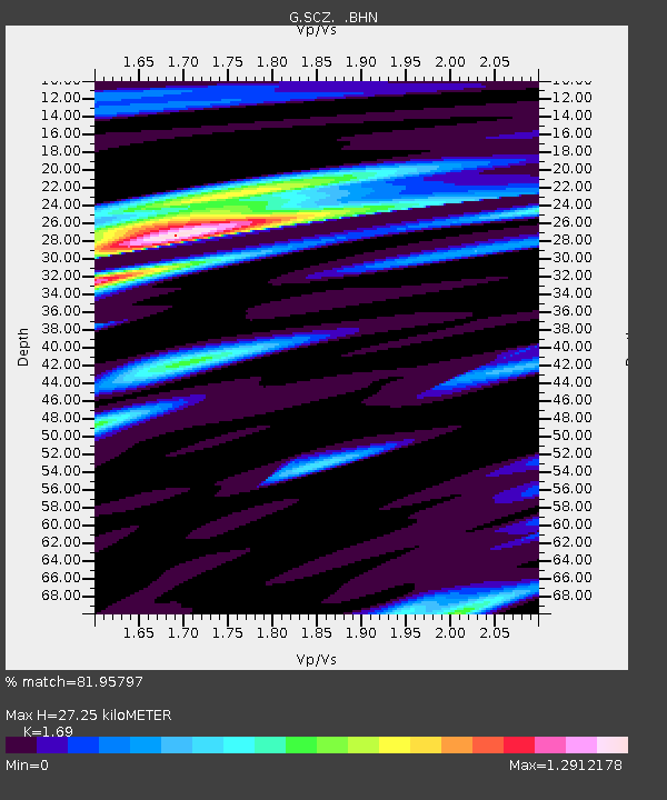
| Estimated Moho Depth: |
27.25 km |
| Estimated Crust Vp/Vs: |
1.69 |
| Assumed Crust Vp: |
6.391 km/s |
| Estimated Crust Vs: |
3.781 km/s |
| Estimated Crust Poisson's Ratio: |
0.23 |
|
| Radial Match: |
81.95797 % |
| Radial Bump: |
400 |
| Transverse Match: |
77.43648 % |
| Transverse Bump: |
400 |
| SOD ConfigId: |
9875 |
| Insert Time: |
2010-02-26 23:51:00.866 +0000 |
| GWidth: |
2.5 |
| Max Bumps: |
400 |
| Tol: |
0.001 |
|

Signal To Noise
| Channel | StoN | STA | LTA |
| G:SCZ: :BHN:19971128T23:03:26.799011Z | 1.637818 | 6.2211507E-7 | 3.7984384E-7 |
| G:SCZ: :BHE:19971128T23:03:26.799011Z | 3.8648517 | 1.0536584E-6 | 2.726258E-7 |
| G:SCZ: :BHZ:19971128T23:03:26.799011Z | 14.739336 | 3.8908966E-6 | 2.6398044E-7 |
| Arrivals |
| Ps | 3.0 SECOND |
| PpPs | 11 SECOND |
| PsPs/PpSs | 14 SECOND |


