You are here: Home > Network List > G - GEOSCOPE Stations List
> Station SCZ Chualar Canyon, Santa Cruz, California, U.S.A. > Earthquake Result Viewer
SCZ Chualar Canyon, Santa Cruz, California, U.S.A. - Earthquake Result Viewer

| Earthquake location: |
Kuril Islands |
| Earthquake latitude/longitude: |
43.2/146.4 |
| Earthquake time(UTC): |
1997/07/14 (195) 16:09:35 GMT |
| Earthquake Depth: |
33 km |
| Earthquake Magnitude: |
5.9 MB, 5.8 MS, 6.1 UNKNOWN, 5.8 ME |
| Earthquake Catalog/Contributor: |
WHDF/NEIC |
|
| Network: |
G GEOSCOPE |
| Station: |
SCZ Chualar Canyon, Santa Cruz, California, U.S.A. |
| Lat/Lon: |
36.60 N/121.40 W |
| Elevation: |
261 m |
|
| Distance: |
67.5 deg |
| Az: |
60.499 deg |
| Baz: |
307.793 deg |
| Ray Param: |
0.05685903 |
| Estimated Moho Depth: |
17.75 km |
| Estimated Crust Vp/Vs: |
2.05 |
| Assumed Crust Vp: |
6.391 km/s |
| Estimated Crust Vs: |
3.125 km/s |
| Estimated Crust Poisson's Ratio: |
0.34 |
|
| Radial Match: |
80.91815 % |
| Radial Bump: |
400 |
| Transverse Match: |
65.48012 % |
| Transverse Bump: |
400 |
| SOD ConfigId: |
6273 |
| Insert Time: |
2010-02-26 23:51:09.631 +0000 |
| GWidth: |
2.5 |
| Max Bumps: |
400 |
| Tol: |
0.001 |
|
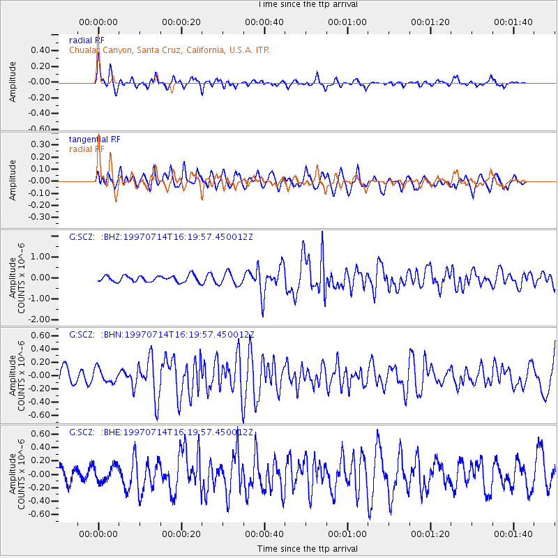
Signal To Noise
| Channel | StoN | STA | LTA |
| G:SCZ: :BHN:19970714T16:19:57.450012Z | 0.8197895 | 1.04543886E-7 | 1.2752528E-7 |
| G:SCZ: :BHE:19970714T16:19:57.450012Z | 1.3522614 | 1.1510873E-7 | 8.512314E-8 |
| G:SCZ: :BHZ:19970714T16:19:57.450012Z | 1.988679 | 2.9621827E-7 | 1.4895228E-7 |
| Arrivals |
| Ps | 3.0 SECOND |
| PpPs | 8.2 SECOND |
| PsPs/PpSs | 11 SECOND |


