You are here: Home > Network List > TA - USArray Transportable Network (new EarthScope stations) Stations List
> Station Z48A Northport, AL, USA > Earthquake Result Viewer
Z48A Northport, AL, USA - Earthquake Result Viewer
| Earthquake location: |
Northern Italy |
| Earthquake latitude/longitude: |
44.9/11.1 |
| Earthquake time(UTC): |
2012/05/29 (150) 07:00:03 GMT |
| Earthquake Depth: |
10 km |
| Earthquake Magnitude: |
5.9 MB, 5.8 MS, 5.8 MW, 5.8 MW |
| Earthquake Catalog/Contributor: |
WHDF/NEIC |
|
| Network: |
TA USArray Transportable Network (new EarthScope stations) |
| Station: |
Z48A Northport, AL, USA |
| Lat/Lon: |
33.38 N/87.56 W |
| Elevation: |
101 m |
|
| Distance: |
72.8 deg |
| Az: |
300.012 deg |
| Baz: |
47.399 deg |
| Ray Param: |
0.05341183 |
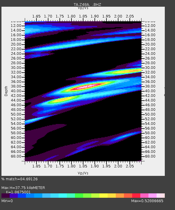
| Estimated Moho Depth: |
37.75 km |
| Estimated Crust Vp/Vs: |
1.87 |
| Assumed Crust Vp: |
6.565 km/s |
| Estimated Crust Vs: |
3.515 km/s |
| Estimated Crust Poisson's Ratio: |
0.30 |
|
| Radial Match: |
84.69126 % |
| Radial Bump: |
400 |
| Transverse Match: |
67.97769 % |
| Transverse Bump: |
400 |
| SOD ConfigId: |
455246 |
| Insert Time: |
2012-09-25 02:37:51.181 +0000 |
| GWidth: |
2.5 |
| Max Bumps: |
400 |
| Tol: |
0.001 |
|
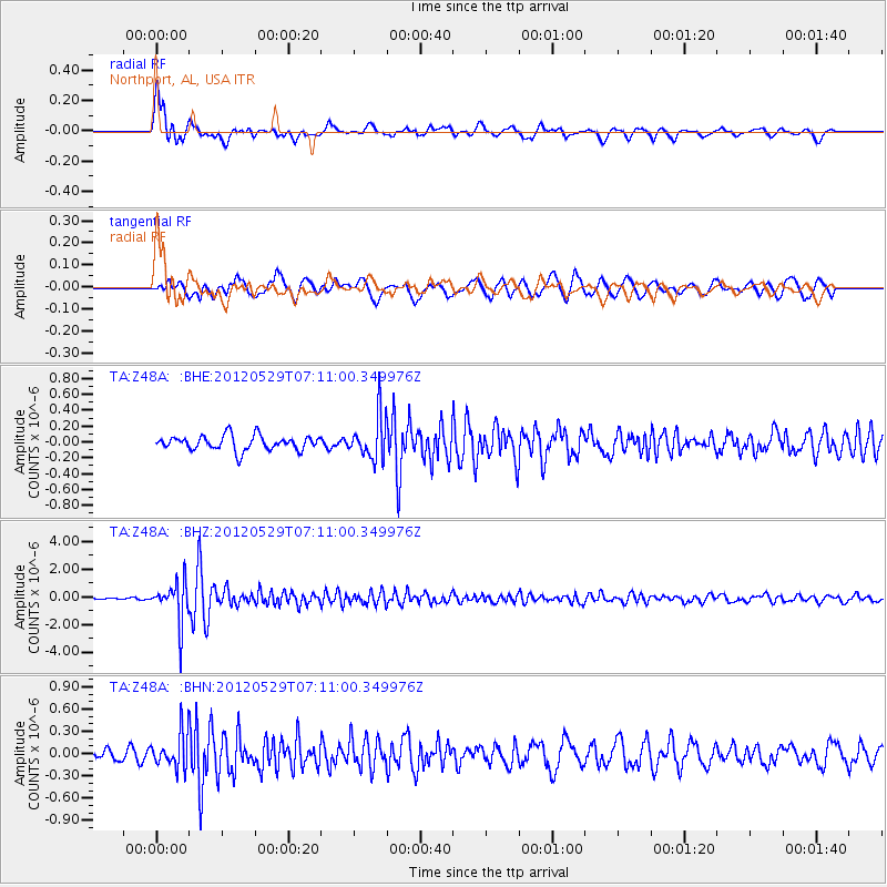
Signal To Noise
| Channel | StoN | STA | LTA |
| TA:Z48A: :BHZ:20120529T07:11:00.349976Z | 27.323032 | 1.4563846E-6 | 5.3302447E-8 |
| TA:Z48A: :BHN:20120529T07:11:00.349976Z | 2.7475426 | 2.3417076E-7 | 8.522916E-8 |
| TA:Z48A: :BHE:20120529T07:11:00.349976Z | 2.9921675 | 2.7239227E-7 | 9.1035105E-8 |
| Arrivals |
| Ps | 5.2 SECOND |
| PpPs | 16 SECOND |
| PsPs/PpSs | 21 SECOND |


