You are here: Home > Network List > TA - USArray Transportable Network (new EarthScope stations) Stations List
> Station Z45A Winona, MS, USA > Earthquake Result Viewer
Z45A Winona, MS, USA - Earthquake Result Viewer

| Earthquake location: |
Northern Italy |
| Earthquake latitude/longitude: |
44.9/11.1 |
| Earthquake time(UTC): |
2012/05/29 (150) 07:00:03 GMT |
| Earthquake Depth: |
10 km |
| Earthquake Magnitude: |
5.9 MB, 5.8 MS, 5.8 MW, 5.8 MW |
| Earthquake Catalog/Contributor: |
WHDF/NEIC |
|
| Network: |
TA USArray Transportable Network (new EarthScope stations) |
| Station: |
Z45A Winona, MS, USA |
| Lat/Lon: |
33.37 N/89.69 W |
| Elevation: |
113 m |
|
| Distance: |
74.1 deg |
| Az: |
301.279 deg |
| Baz: |
46.59 deg |
| Ray Param: |
0.05254215 |
| Estimated Moho Depth: |
38.5 km |
| Estimated Crust Vp/Vs: |
1.75 |
| Assumed Crust Vp: |
6.201 km/s |
| Estimated Crust Vs: |
3.539 km/s |
| Estimated Crust Poisson's Ratio: |
0.26 |
|
| Radial Match: |
82.4619 % |
| Radial Bump: |
400 |
| Transverse Match: |
69.795586 % |
| Transverse Bump: |
400 |
| SOD ConfigId: |
455246 |
| Insert Time: |
2012-09-25 02:38:06.436 +0000 |
| GWidth: |
2.5 |
| Max Bumps: |
400 |
| Tol: |
0.001 |
|
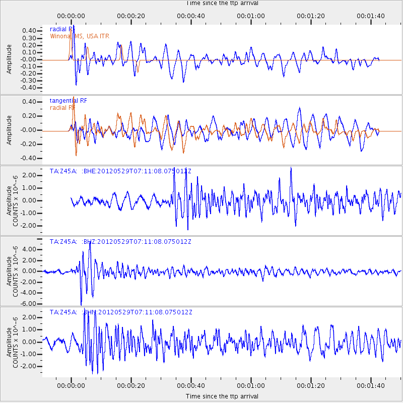
Signal To Noise
| Channel | StoN | STA | LTA |
| TA:Z45A: :BHZ:20120529T07:11:08.075012Z | 14.809039 | 1.7877501E-6 | 1.207202E-7 |
| TA:Z45A: :BHN:20120529T07:11:08.075012Z | 2.294354 | 8.0476804E-7 | 3.507602E-7 |
| TA:Z45A: :BHE:20120529T07:11:08.075012Z | 2.0835314 | 6.6503867E-7 | 3.1918825E-7 |
| Arrivals |
| Ps | 4.8 SECOND |
| PpPs | 17 SECOND |
| PsPs/PpSs | 21 SECOND |


