You are here: Home > Network List > G - GEOSCOPE Stations List
> Station SCZ Chualar Canyon, Santa Cruz, California, U.S.A. > Earthquake Result Viewer
SCZ Chualar Canyon, Santa Cruz, California, U.S.A. - Earthquake Result Viewer
| Earthquake location: |
Off Coast Of Central America |
| Earthquake latitude/longitude: |
11.7/-88.0 |
| Earthquake time(UTC): |
1998/08/23 (235) 13:57:15 GMT |
| Earthquake Depth: |
55 km |
| Earthquake Magnitude: |
5.7 MB, 6.3 MS, 6.8 UNKNOWN, 6.7 MW |
| Earthquake Catalog/Contributor: |
WHDF/NEIC |
|
| Network: |
G GEOSCOPE |
| Station: |
SCZ Chualar Canyon, Santa Cruz, California, U.S.A. |
| Lat/Lon: |
36.60 N/121.40 W |
| Elevation: |
261 m |
|
| Distance: |
39.0 deg |
| Az: |
315.253 deg |
| Baz: |
121.025 deg |
| Ray Param: |
0.07511415 |
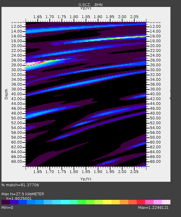
| Estimated Moho Depth: |
27.5 km |
| Estimated Crust Vp/Vs: |
1.60 |
| Assumed Crust Vp: |
6.391 km/s |
| Estimated Crust Vs: |
3.988 km/s |
| Estimated Crust Poisson's Ratio: |
0.18 |
|
| Radial Match: |
91.37706 % |
| Radial Bump: |
400 |
| Transverse Match: |
82.124596 % |
| Transverse Bump: |
400 |
| SOD ConfigId: |
9875 |
| Insert Time: |
2010-02-26 23:51:20.402 +0000 |
| GWidth: |
2.5 |
| Max Bumps: |
400 |
| Tol: |
0.001 |
|
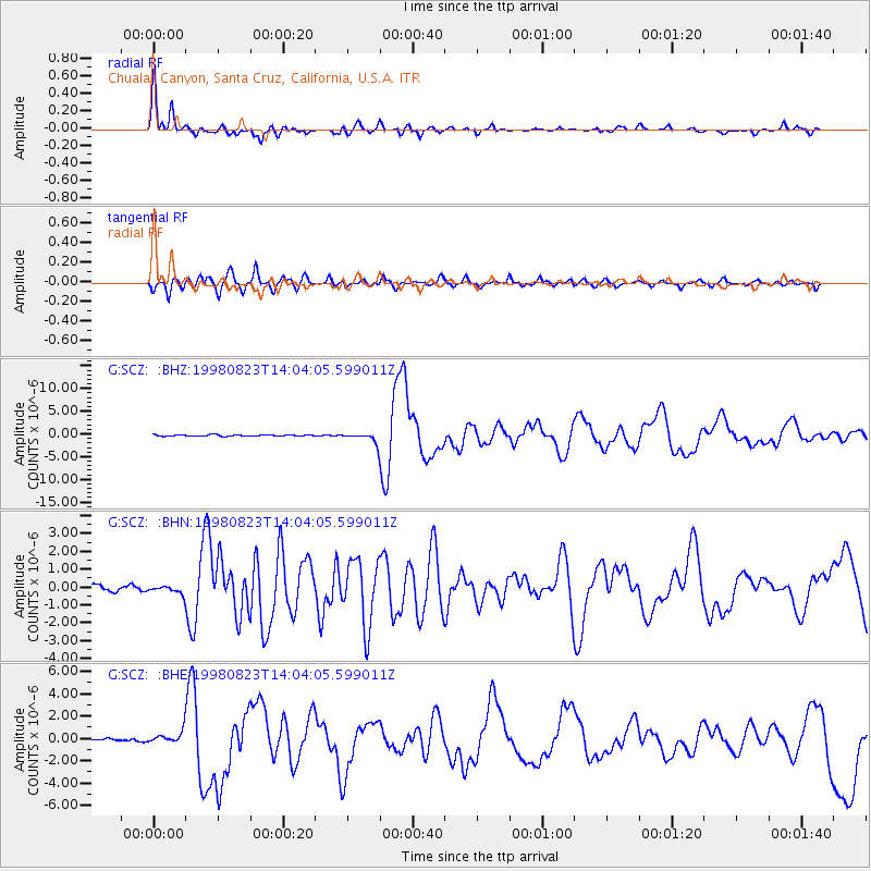
Signal To Noise
| Channel | StoN | STA | LTA |
| G:SCZ: :BHN:19980823T14:04:05.599011Z | 1.3013986 | 2.1365975E-7 | 1.6417701E-7 |
| G:SCZ: :BHE:19980823T14:04:05.599011Z | 5.686604 | 5.4930746E-7 | 9.659675E-8 |
| G:SCZ: :BHZ:19980823T14:04:05.599011Z | 7.998869 | 1.1459814E-6 | 1.4326793E-7 |
| Arrivals |
| Ps | 2.8 SECOND |
| PpPs | 10 SECOND |
| PsPs/PpSs | 13 SECOND |


