You are here: Home > Network List > TA - USArray Transportable Network (new EarthScope stations) Stations List
> Station X42A Stuttgart, AR, USA > Earthquake Result Viewer
X42A Stuttgart, AR, USA - Earthquake Result Viewer
| Earthquake location: |
Northern Italy |
| Earthquake latitude/longitude: |
44.9/11.1 |
| Earthquake time(UTC): |
2012/05/29 (150) 07:00:03 GMT |
| Earthquake Depth: |
10 km |
| Earthquake Magnitude: |
5.9 MB, 5.8 MS, 5.8 MW, 5.8 MW |
| Earthquake Catalog/Contributor: |
WHDF/NEIC |
|
| Network: |
TA USArray Transportable Network (new EarthScope stations) |
| Station: |
X42A Stuttgart, AR, USA |
| Lat/Lon: |
34.55 N/91.63 W |
| Elevation: |
62 m |
|
| Distance: |
74.5 deg |
| Az: |
303.319 deg |
| Baz: |
46.066 deg |
| Ray Param: |
0.052307695 |
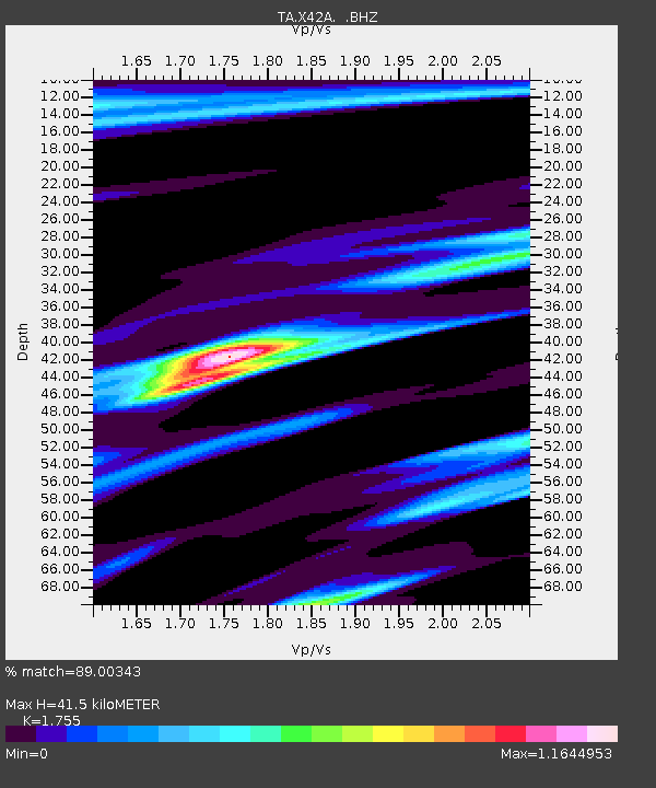
| Estimated Moho Depth: |
41.5 km |
| Estimated Crust Vp/Vs: |
1.75 |
| Assumed Crust Vp: |
6.273 km/s |
| Estimated Crust Vs: |
3.574 km/s |
| Estimated Crust Poisson's Ratio: |
0.26 |
|
| Radial Match: |
89.00343 % |
| Radial Bump: |
400 |
| Transverse Match: |
73.79147 % |
| Transverse Bump: |
400 |
| SOD ConfigId: |
455246 |
| Insert Time: |
2012-09-25 02:42:05.539 +0000 |
| GWidth: |
2.5 |
| Max Bumps: |
400 |
| Tol: |
0.001 |
|
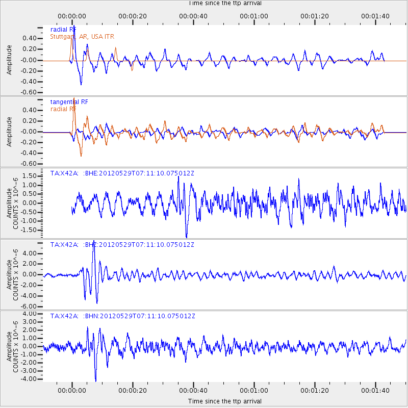
Signal To Noise
| Channel | StoN | STA | LTA |
| TA:X42A: :BHZ:20120529T07:11:10.075012Z | 9.027144 | 1.2894096E-6 | 1.4283694E-7 |
| TA:X42A: :BHN:20120529T07:11:10.075012Z | 1.4459983 | 3.8467385E-7 | 2.660265E-7 |
| TA:X42A: :BHE:20120529T07:11:10.075012Z | 1.1080841 | 4.0326324E-7 | 3.6392836E-7 |
| Arrivals |
| Ps | 5.2 SECOND |
| PpPs | 18 SECOND |
| PsPs/PpSs | 23 SECOND |


