You are here: Home > Network List > TA - USArray Transportable Network (new EarthScope stations) Stations List
> Station H40A Chili, WI, USA > Earthquake Result Viewer
H40A Chili, WI, USA - Earthquake Result Viewer
| Earthquake location: |
Northern Italy |
| Earthquake latitude/longitude: |
44.9/11.1 |
| Earthquake time(UTC): |
2012/05/29 (150) 07:00:03 GMT |
| Earthquake Depth: |
10 km |
| Earthquake Magnitude: |
5.9 MB, 5.8 MS, 5.8 MW, 5.8 MW |
| Earthquake Catalog/Contributor: |
WHDF/NEIC |
|
| Network: |
TA USArray Transportable Network (new EarthScope stations) |
| Station: |
H40A Chili, WI, USA |
| Lat/Lon: |
44.62 N/90.39 W |
| Elevation: |
372 m |
|
| Distance: |
67.0 deg |
| Az: |
310.504 deg |
| Baz: |
49.233 deg |
| Ray Param: |
0.057252154 |
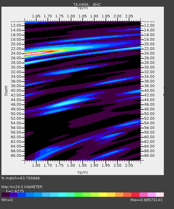
| Estimated Moho Depth: |
24.0 km |
| Estimated Crust Vp/Vs: |
1.63 |
| Assumed Crust Vp: |
6.571 km/s |
| Estimated Crust Vs: |
4.037 km/s |
| Estimated Crust Poisson's Ratio: |
0.20 |
|
| Radial Match: |
83.788666 % |
| Radial Bump: |
284 |
| Transverse Match: |
69.19119 % |
| Transverse Bump: |
342 |
| SOD ConfigId: |
455246 |
| Insert Time: |
2012-09-25 02:42:31.841 +0000 |
| GWidth: |
2.5 |
| Max Bumps: |
400 |
| Tol: |
0.001 |
|
Signal To Noise
| Channel | StoN | STA | LTA |
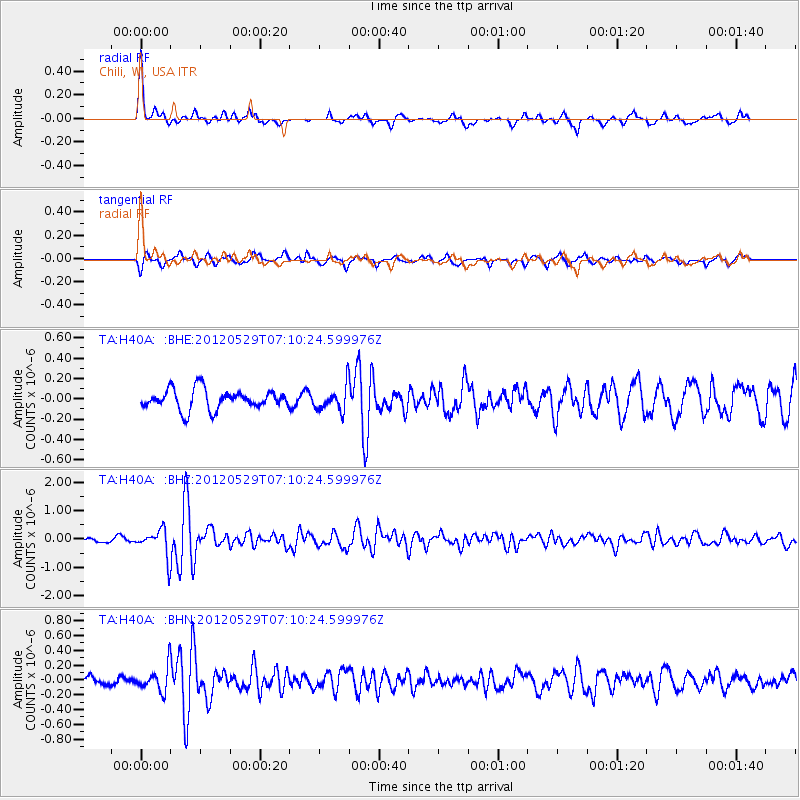
| TA:H40A: :BHZ:20120529T07:10:24.599976Z | 6.0481095 | 4.746674E-7 | 7.8481946E-8 |
| TA:H40A: :BHN:20120529T07:10:24.599976Z | 3.387094 | 1.6189527E-7 | 4.7797688E-8 |
| TA:H40A: :BHE:20120529T07:10:24.599976Z | 1.2403007 | 1.2048402E-7 | 9.714098E-8 |
| Arrivals |
| Ps | 2.4 SECOND |
| PpPs | 9.2 SECOND |
| PsPs/PpSs | 12 SECOND |


