You are here: Home > Network List > TA - USArray Transportable Network (new EarthScope stations) Stations List
> Station E40A Wakefield, MI, USA > Earthquake Result Viewer
E40A Wakefield, MI, USA - Earthquake Result Viewer
| Earthquake location: |
Northern Italy |
| Earthquake latitude/longitude: |
44.9/11.1 |
| Earthquake time(UTC): |
2012/05/29 (150) 07:00:03 GMT |
| Earthquake Depth: |
10 km |
| Earthquake Magnitude: |
5.9 MB, 5.8 MS, 5.8 MW, 5.8 MW |
| Earthquake Catalog/Contributor: |
WHDF/NEIC |
|
| Network: |
TA USArray Transportable Network (new EarthScope stations) |
| Station: |
E40A Wakefield, MI, USA |
| Lat/Lon: |
46.44 N/89.90 W |
| Elevation: |
472 m |
|
| Distance: |
65.5 deg |
| Az: |
311.778 deg |
| Baz: |
50.095 deg |
| Ray Param: |
0.05820334 |
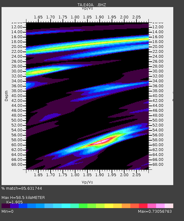
| Estimated Moho Depth: |
58.5 km |
| Estimated Crust Vp/Vs: |
1.90 |
| Assumed Crust Vp: |
6.467 km/s |
| Estimated Crust Vs: |
3.395 km/s |
| Estimated Crust Poisson's Ratio: |
0.31 |
|
| Radial Match: |
85.631744 % |
| Radial Bump: |
335 |
| Transverse Match: |
72.6372 % |
| Transverse Bump: |
400 |
| SOD ConfigId: |
455246 |
| Insert Time: |
2012-09-25 02:45:00.362 +0000 |
| GWidth: |
2.5 |
| Max Bumps: |
400 |
| Tol: |
0.001 |
|

Signal To Noise
| Channel | StoN | STA | LTA |
| TA:E40A: :BHZ:20120529T07:10:15.375Z | 4.217362 | 4.552053E-7 | 1.07936025E-7 |
| TA:E40A: :BHN:20120529T07:10:15.375Z | 1.2210233 | 1.2463445E-7 | 1.0207378E-7 |
| TA:E40A: :BHE:20120529T07:10:15.375Z | 2.6295135 | 7.971269E-8 | 3.0314617E-8 |
| Arrivals |
| Ps | 8.5 SECOND |
| PpPs | 25 SECOND |
| PsPs/PpSs | 34 SECOND |


