You are here: Home > Network List > TA - USArray Transportable Network (new EarthScope stations) Stations List
> Station E44A Grand Marais Airport, Grand Marais, MI, USA > Earthquake Result Viewer
E44A Grand Marais Airport, Grand Marais, MI, USA - Earthquake Result Viewer
| Earthquake location: |
Northern Italy |
| Earthquake latitude/longitude: |
44.9/11.1 |
| Earthquake time(UTC): |
2012/05/29 (150) 07:00:03 GMT |
| Earthquake Depth: |
10 km |
| Earthquake Magnitude: |
5.9 MB, 5.8 MS, 5.8 MW, 5.8 MW |
| Earthquake Catalog/Contributor: |
WHDF/NEIC |
|
| Network: |
TA USArray Transportable Network (new EarthScope stations) |
| Station: |
E44A Grand Marais Airport, Grand Marais, MI, USA |
| Lat/Lon: |
46.62 N/85.92 W |
| Elevation: |
282 m |
|
| Distance: |
63.3 deg |
| Az: |
310.02 deg |
| Baz: |
52.214 deg |
| Ray Param: |
0.059670452 |
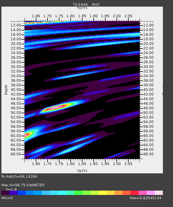
| Estimated Moho Depth: |
59.75 km |
| Estimated Crust Vp/Vs: |
1.60 |
| Assumed Crust Vp: |
6.467 km/s |
| Estimated Crust Vs: |
4.042 km/s |
| Estimated Crust Poisson's Ratio: |
0.18 |
|
| Radial Match: |
84.14264 % |
| Radial Bump: |
400 |
| Transverse Match: |
68.70275 % |
| Transverse Bump: |
400 |
| SOD ConfigId: |
455246 |
| Insert Time: |
2012-09-25 02:46:00.981 +0000 |
| GWidth: |
2.5 |
| Max Bumps: |
400 |
| Tol: |
0.001 |
|
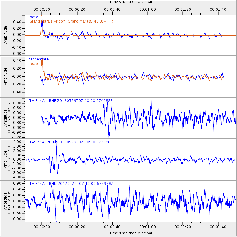
Signal To Noise
| Channel | StoN | STA | LTA |
| TA:E44A: :BHZ:20120529T07:10:00.674988Z | 2.3662374 | 4.111606E-7 | 1.7376136E-7 |
| TA:E44A: :BHN:20120529T07:10:00.674988Z | 1.6532018 | 2.8910344E-7 | 1.7487487E-7 |
| TA:E44A: :BHE:20120529T07:10:00.674988Z | 1.1097713 | 1.8468279E-7 | 1.6641519E-7 |
| Arrivals |
| Ps | 5.8 SECOND |
| PpPs | 23 SECOND |
| PsPs/PpSs | 29 SECOND |


