You are here: Home > Network List > TA - USArray Transportable Network (new EarthScope stations) Stations List
> Station G42A Mountain, WI, USA > Earthquake Result Viewer
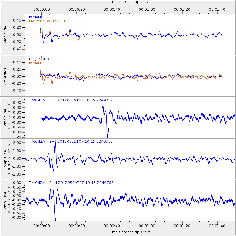
G42A Mountain, WI, USA - Earthquake Result Viewer
*The percent match for this event was below the threshold and hence no stack was calculated.
| Earthquake location: |
Northern Italy |
| Earthquake latitude/longitude: |
44.9/11.1 |
| Earthquake time(UTC): |
2012/05/29 (150) 07:00:03 GMT |
| Earthquake Depth: |
10 km |
| Earthquake Magnitude: |
5.9 MB, 5.8 MS, 5.8 MW, 5.8 MW |
| Earthquake Catalog/Contributor: |
WHDF/NEIC |
|
| Network: |
TA USArray Transportable Network (new EarthScope stations) |
| Station: |
G42A Mountain, WI, USA |
| Lat/Lon: |
45.24 N/88.43 W |
| Elevation: |
315 m |
|
| Distance: |
65.5 deg |
| Az: |
310.039 deg |
| Baz: |
50.427 deg |
| Ray Param: |
$rayparam |
*The percent match for this event was below the threshold and hence was not used in the summary stack. |
|
| Radial Match: |
77.106834 % |
| Radial Bump: |
328 |
| Transverse Match: |
56.920006 % |
| Transverse Bump: |
400 |
| SOD ConfigId: |
455246 |
| Insert Time: |
2012-09-25 02:46:24.984 +0000 |
| GWidth: |
2.5 |
| Max Bumps: |
400 |
| Tol: |
0.001 |
|
Signal To Noise
| Channel | StoN | STA | LTA |
| TA:G42A: :BHZ:20120529T07:10:15.224976Z | 2.8612018 | 4.1322545E-7 | 1.4442374E-7 |
| TA:G42A: :BHN:20120529T07:10:15.224976Z | 1.9529496 | 1.682653E-7 | 8.6159574E-8 |
| TA:G42A: :BHE:20120529T07:10:15.224976Z | 2.845332 | 2.2513109E-7 | 7.912296E-8 |
| Arrivals |
| Ps | |
| PpPs | |
| PsPs/PpSs | |


