You are here: Home > Network List > TA - USArray Transportable Network (new EarthScope stations) Stations List
> Station N45A Kentland, IN, USA > Earthquake Result Viewer
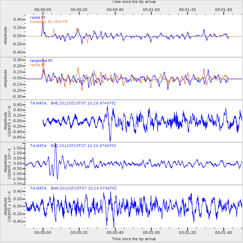
N45A Kentland, IN, USA - Earthquake Result Viewer
*The percent match for this event was below the threshold and hence no stack was calculated.
| Earthquake location: |
Northern Italy |
| Earthquake latitude/longitude: |
44.9/11.1 |
| Earthquake time(UTC): |
2012/05/29 (150) 07:00:03 GMT |
| Earthquake Depth: |
10 km |
| Earthquake Magnitude: |
5.9 MB, 5.8 MS, 5.8 MW, 5.8 MW |
| Earthquake Catalog/Contributor: |
WHDF/NEIC |
|
| Network: |
TA USArray Transportable Network (new EarthScope stations) |
| Station: |
N45A Kentland, IN, USA |
| Lat/Lon: |
40.85 N/87.51 W |
| Elevation: |
206 m |
|
| Distance: |
67.8 deg |
| Az: |
305.909 deg |
| Baz: |
49.415 deg |
| Ray Param: |
$rayparam |
*The percent match for this event was below the threshold and hence was not used in the summary stack. |
|
| Radial Match: |
74.45978 % |
| Radial Bump: |
342 |
| Transverse Match: |
68.96816 % |
| Transverse Bump: |
388 |
| SOD ConfigId: |
455246 |
| Insert Time: |
2012-09-25 02:46:53.236 +0000 |
| GWidth: |
2.5 |
| Max Bumps: |
400 |
| Tol: |
0.001 |
|
Signal To Noise
| Channel | StoN | STA | LTA |
| TA:N45A: :BHZ:20120529T07:10:29.974976Z | 4.2507696 | 4.502068E-7 | 1.0591184E-7 |
| TA:N45A: :BHN:20120529T07:10:29.974976Z | 1.4541065 | 1.500509E-7 | 1.03191134E-7 |
| TA:N45A: :BHE:20120529T07:10:29.974976Z | 1.5503731 | 1.4655441E-7 | 9.452848E-8 |
| Arrivals |
| Ps | |
| PpPs | |
| PsPs/PpSs | |


