You are here: Home > Network List > G - GEOSCOPE Stations List
> Station SCZ Chualar Canyon, Santa Cruz, California, U.S.A. > Earthquake Result Viewer
SCZ Chualar Canyon, Santa Cruz, California, U.S.A. - Earthquake Result Viewer
| Earthquake location: |
South Of Kermadec Islands |
| Earthquake latitude/longitude: |
-32.1/179.8 |
| Earthquake time(UTC): |
1997/05/25 (145) 23:22:33 GMT |
| Earthquake Depth: |
333 km |
| Earthquake Magnitude: |
6.2 MB, 7.1 UNKNOWN, 7.0 MW |
| Earthquake Catalog/Contributor: |
WHDF/NEIC |
|
| Network: |
G GEOSCOPE |
| Station: |
SCZ Chualar Canyon, Santa Cruz, California, U.S.A. |
| Lat/Lon: |
36.60 N/121.40 W |
| Elevation: |
261 m |
|
| Distance: |
87.7 deg |
| Az: |
43.546 deg |
| Baz: |
226.591 deg |
| Ray Param: |
0.042272624 |
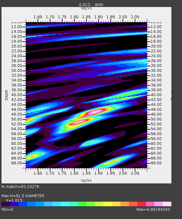
| Estimated Moho Depth: |
51.0 km |
| Estimated Crust Vp/Vs: |
1.82 |
| Assumed Crust Vp: |
6.391 km/s |
| Estimated Crust Vs: |
3.521 km/s |
| Estimated Crust Poisson's Ratio: |
0.28 |
|
| Radial Match: |
83.33279 % |
| Radial Bump: |
400 |
| Transverse Match: |
90.49967 % |
| Transverse Bump: |
327 |
| SOD ConfigId: |
4480 |
| Insert Time: |
2010-02-26 23:51:35.778 +0000 |
| GWidth: |
2.5 |
| Max Bumps: |
400 |
| Tol: |
0.001 |
|
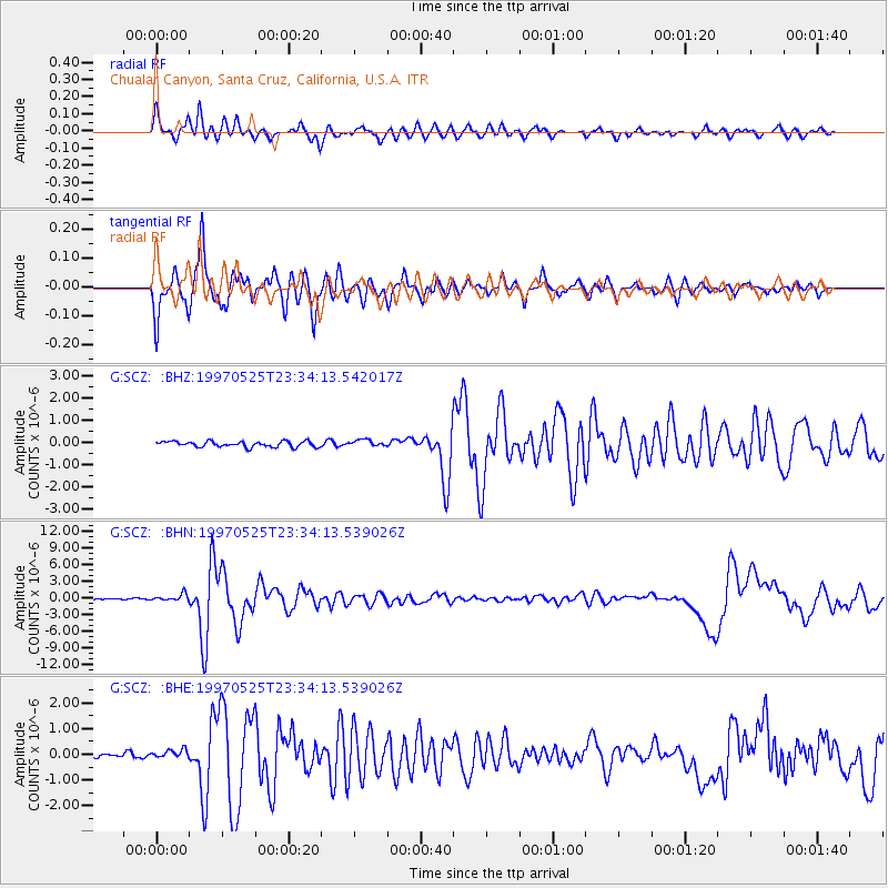
Signal To Noise
| Channel | StoN | STA | LTA |
| G:SCZ: :BHN:19970525T23:34:13.539026Z | 6.367917 | 6.234327E-7 | 9.790214E-8 |
| G:SCZ: :BHE:19970525T23:34:13.539026Z | 1.7111742 | 1.5767154E-7 | 9.214231E-8 |
| G:SCZ: :BHZ:19970525T23:34:13.542017Z | 1.1753995 | 1.488542E-7 | 1.2664137E-7 |
| Arrivals |
| Ps | 6.6 SECOND |
| PpPs | 22 SECOND |
| PsPs/PpSs | 29 SECOND |


