You are here: Home > Network List > TA - USArray Transportable Network (new EarthScope stations) Stations List
> Station Y48A Jasper, AL, USA > Earthquake Result Viewer
Y48A Jasper, AL, USA - Earthquake Result Viewer
| Earthquake location: |
Northern Italy |
| Earthquake latitude/longitude: |
44.9/11.1 |
| Earthquake time(UTC): |
2012/05/29 (150) 07:00:03 GMT |
| Earthquake Depth: |
10 km |
| Earthquake Magnitude: |
5.9 MB, 5.8 MS, 5.8 MW, 5.8 MW |
| Earthquake Catalog/Contributor: |
WHDF/NEIC |
|
| Network: |
TA USArray Transportable Network (new EarthScope stations) |
| Station: |
Y48A Jasper, AL, USA |
| Lat/Lon: |
33.91 N/87.17 W |
| Elevation: |
170 m |
|
| Distance: |
72.2 deg |
| Az: |
300.198 deg |
| Baz: |
47.668 deg |
| Ray Param: |
0.05380708 |
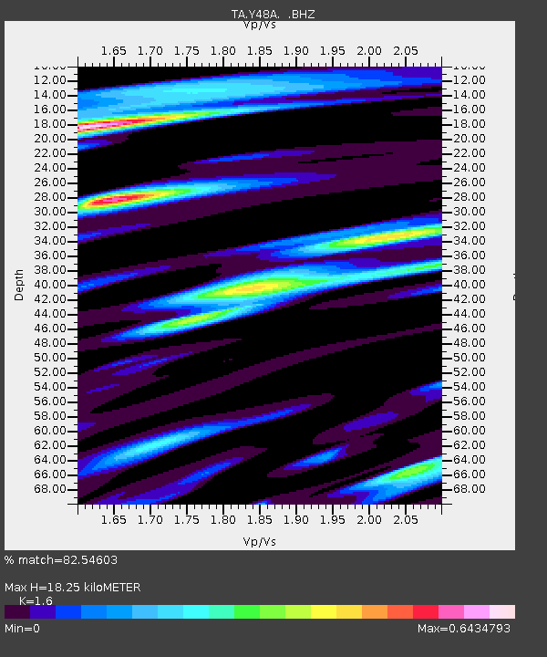
| Estimated Moho Depth: |
18.25 km |
| Estimated Crust Vp/Vs: |
1.60 |
| Assumed Crust Vp: |
6.565 km/s |
| Estimated Crust Vs: |
4.103 km/s |
| Estimated Crust Poisson's Ratio: |
0.18 |
|
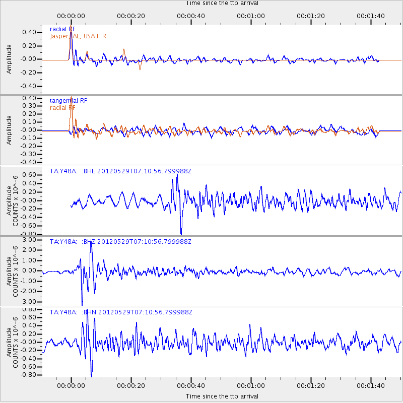
| Radial Match: |
82.54603 % |
| Radial Bump: |
400 |
| Transverse Match: |
52.27683 % |
| Transverse Bump: |
400 |
| SOD ConfigId: |
455246 |
| Insert Time: |
2012-09-25 02:50:47.800 +0000 |
| GWidth: |
2.5 |
| Max Bumps: |
400 |
| Tol: |
0.001 |
|
Signal To Noise
| Channel | StoN | STA | LTA |
| TA:Y48A: :BHZ:20120529T07:10:56.799988Z | 10.890787 | 8.7365214E-7 | 8.021938E-8 |
| TA:Y48A: :BHN:20120529T07:10:56.799988Z | 1.3564278 | 1.8219846E-7 | 1.3432228E-7 |
| TA:Y48A: :BHE:20120529T07:10:56.799988Z | 1.8240848 | 1.7688107E-7 | 9.696977E-8 |
| Arrivals |
| Ps | 1.7 SECOND |
| PpPs | 6.9 SECOND |
| PsPs/PpSs | 8.7 SECOND |


