You are here: Home > Network List > G - GEOSCOPE Stations List
> Station SCZ Chualar Canyon, Santa Cruz, California, U.S.A. > Earthquake Result Viewer
SCZ Chualar Canyon, Santa Cruz, California, U.S.A. - Earthquake Result Viewer

| Earthquake location: |
Southern Pacific Ocean |
| Earthquake latitude/longitude: |
-36.0/-102.5 |
| Earthquake time(UTC): |
1997/05/29 (149) 17:02:38 GMT |
| Earthquake Depth: |
10 km |
| Earthquake Magnitude: |
5.6 MB, 6.1 MS, 6.5 UNKNOWN, 6.4 MW |
| Earthquake Catalog/Contributor: |
WHDF/NEIC |
|
| Network: |
G GEOSCOPE |
| Station: |
SCZ Chualar Canyon, Santa Cruz, California, U.S.A. |
| Lat/Lon: |
36.60 N/121.40 W |
| Elevation: |
261 m |
|
| Distance: |
74.3 deg |
| Az: |
344.296 deg |
| Baz: |
164.166 deg |
| Ray Param: |
0.052426483 |
| Estimated Moho Depth: |
28.0 km |
| Estimated Crust Vp/Vs: |
2.03 |
| Assumed Crust Vp: |
6.391 km/s |
| Estimated Crust Vs: |
3.148 km/s |
| Estimated Crust Poisson's Ratio: |
0.34 |
|
| Radial Match: |
87.733925 % |
| Radial Bump: |
379 |
| Transverse Match: |
87.42908 % |
| Transverse Bump: |
400 |
| SOD ConfigId: |
4480 |
| Insert Time: |
2010-02-26 23:51:38.260 +0000 |
| GWidth: |
2.5 |
| Max Bumps: |
400 |
| Tol: |
0.001 |
|
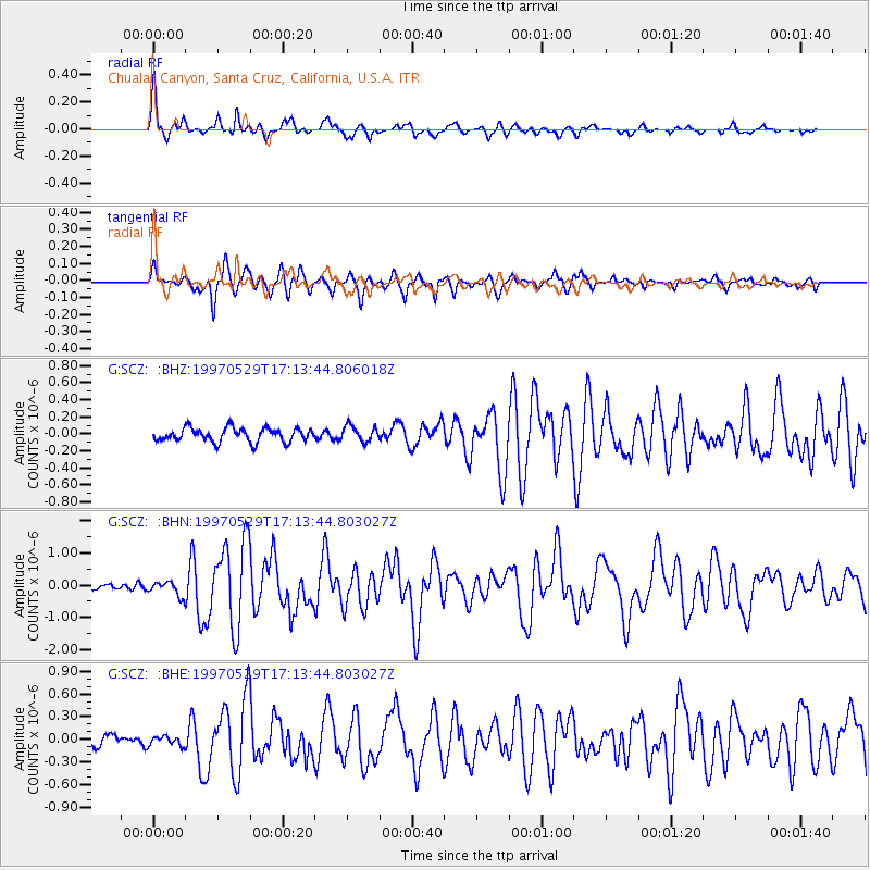
Signal To Noise
| Channel | StoN | STA | LTA |
| G:SCZ: :BHN:19970529T17:13:44.803027Z | 3.8260508 | 2.2024406E-7 | 5.7564332E-8 |
| G:SCZ: :BHE:19970529T17:13:44.803027Z | 0.6555131 | 6.28666E-8 | 9.5904404E-8 |
| G:SCZ: :BHZ:19970529T17:13:44.806018Z | 1.1724683 | 9.4293334E-8 | 8.042293E-8 |
| Arrivals |
| Ps | 4.6 SECOND |
| PpPs | 13 SECOND |
| PsPs/PpSs | 18 SECOND |


