You are here: Home > Network List > G - GEOSCOPE Stations List
> Station SCZ Chualar Canyon, Santa Cruz, California, U.S.A. > Earthquake Result Viewer
SCZ Chualar Canyon, Santa Cruz, California, U.S.A. - Earthquake Result Viewer
| Earthquake location: |
Andreanof Islands, Aleutian Is. |
| Earthquake latitude/longitude: |
51.3/-179.3 |
| Earthquake time(UTC): |
1997/06/17 (168) 21:03:40 GMT |
| Earthquake Depth: |
33 km |
| Earthquake Magnitude: |
6.4 MB, 6.3 MS, 6.4 UNKNOWN, 6.6 ML |
| Earthquake Catalog/Contributor: |
WHDF/NEIC |
|
| Network: |
G GEOSCOPE |
| Station: |
SCZ Chualar Canyon, Santa Cruz, California, U.S.A. |
| Lat/Lon: |
36.60 N/121.40 W |
| Elevation: |
261 m |
|
| Distance: |
43.1 deg |
| Az: |
86.687 deg |
| Baz: |
308.92 deg |
| Ray Param: |
0.07271187 |
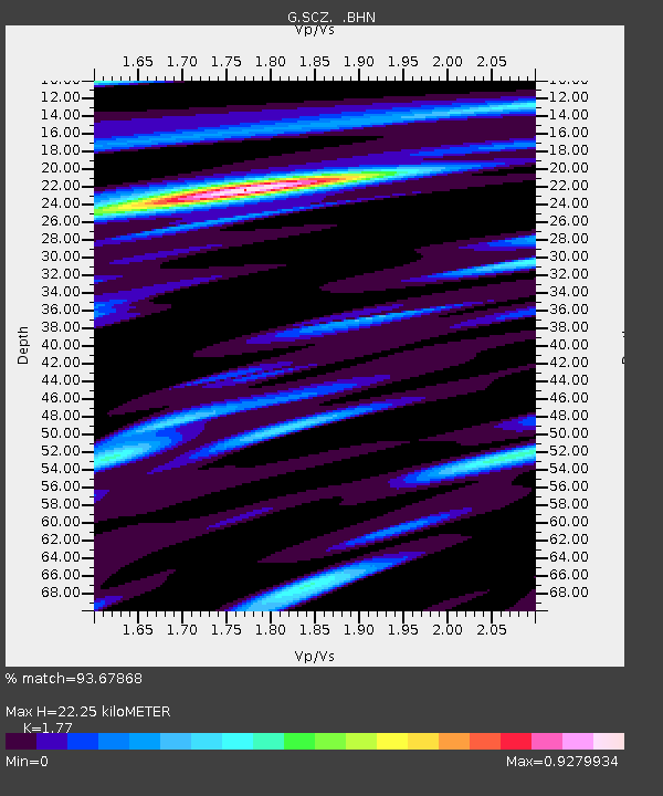
| Estimated Moho Depth: |
22.25 km |
| Estimated Crust Vp/Vs: |
1.77 |
| Assumed Crust Vp: |
6.391 km/s |
| Estimated Crust Vs: |
3.611 km/s |
| Estimated Crust Poisson's Ratio: |
0.27 |
|
| Radial Match: |
93.67868 % |
| Radial Bump: |
328 |
| Transverse Match: |
77.13415 % |
| Transverse Bump: |
400 |
| SOD ConfigId: |
4480 |
| Insert Time: |
2010-02-26 23:51:40.144 +0000 |
| GWidth: |
2.5 |
| Max Bumps: |
400 |
| Tol: |
0.001 |
|

Signal To Noise
| Channel | StoN | STA | LTA |
| G:SCZ: :BHN:19970617T21:11:06.577991Z | 12.606831 | 2.4280391E-6 | 1.925971E-7 |
| G:SCZ: :BHE:19970617T21:11:06.577991Z | 3.5476096 | 6.4878395E-7 | 1.8287919E-7 |
| G:SCZ: :BHZ:19970617T21:11:06.577991Z | 7.4034953 | 1.155587E-6 | 1.5608668E-7 |
| Arrivals |
| Ps | 2.9 SECOND |
| PpPs | 9.0 SECOND |
| PsPs/PpSs | 12 SECOND |


