You are here: Home > Network List > GS - US Geological Survey Networks Stations List
> Station DEC09 Decatur Surface Seismic Site, Decatur, IL, USA > Earthquake Result Viewer
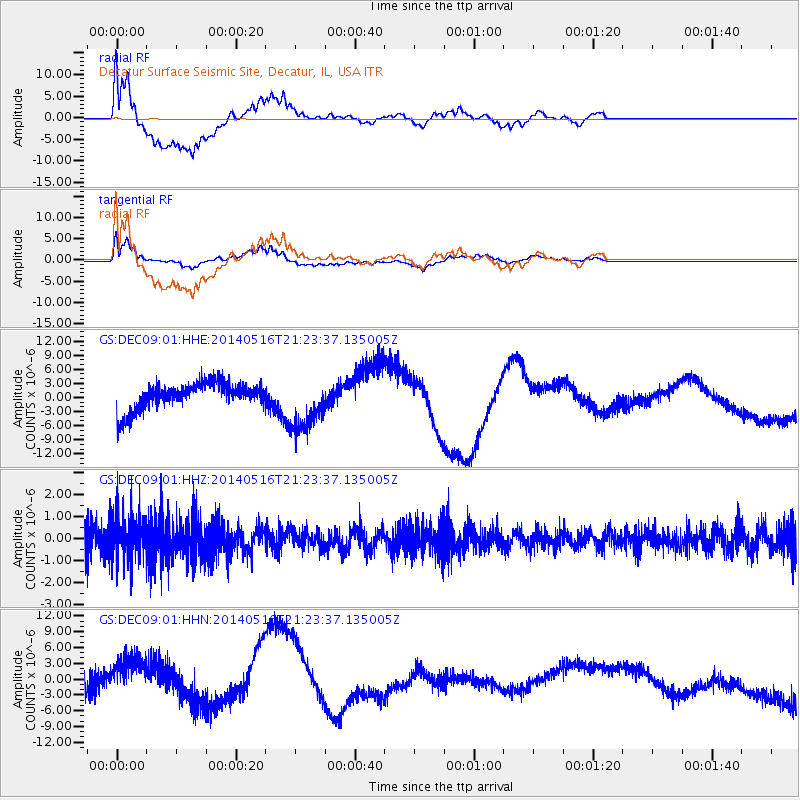
DEC09 Decatur Surface Seismic Site, Decatur, IL, USA - Earthquake Result Viewer
*The percent match for this event was below the threshold and hence no stack was calculated.
| Earthquake location: |
Ascension Island Region |
| Earthquake latitude/longitude: |
-10.4/-13.2 |
| Earthquake time(UTC): |
2014/05/16 (136) 21:11:29 GMT |
| Earthquake Depth: |
12 km |
| Earthquake Magnitude: |
4.9 MW |
| Earthquake Catalog/Contributor: |
ISC/ISC |
|
| Network: |
GS US Geological Survey Networks |
| Station: |
DEC09 Decatur Surface Seismic Site, Decatur, IL, USA |
| Lat/Lon: |
39.87 N/88.92 W |
| Elevation: |
207 m |
|
| Distance: |
85.9 deg |
| Az: |
311.605 deg |
| Baz: |
107.096 deg |
| Ray Param: |
$rayparam |
*The percent match for this event was below the threshold and hence was not used in the summary stack. |
|
| Radial Match: |
59.83576 % |
| Radial Bump: |
400 |
| Transverse Match: |
56.66694 % |
| Transverse Bump: |
400 |
| SOD ConfigId: |
3390531 |
| Insert Time: |
2019-04-11 22:13:31.269 +0000 |
| GWidth: |
2.5 |
| Max Bumps: |
400 |
| Tol: |
0.001 |
|
Signal To Noise
| Channel | StoN | STA | LTA |
| GS:DEC09:01:HHZ:20140516T21:23:37.135005Z | 1.2937006 | 1.053365E-6 | 8.142263E-7 |
| GS:DEC09:01:HHN:20140516T21:23:37.135005Z | 3.1291716 | 5.4255165E-6 | 1.7338508E-6 |
| GS:DEC09:01:HHE:20140516T21:23:37.135005Z | 2.0007665 | 5.8321825E-6 | 2.914974E-6 |
| Arrivals |
| Ps | |
| PpPs | |
| PsPs/PpSs | |


