You are here: Home > Network List > G - GEOSCOPE Stations List
> Station SCZ Chualar Canyon, Santa Cruz, California, U.S.A. > Earthquake Result Viewer
SCZ Chualar Canyon, Santa Cruz, California, U.S.A. - Earthquake Result Viewer
| Earthquake location: |
Volcano Islands, Japan Region |
| Earthquake latitude/longitude: |
22.3/143.7 |
| Earthquake time(UTC): |
2000/03/28 (088) 11:00:22 GMT |
| Earthquake Depth: |
126 km |
| Earthquake Magnitude: |
6.8 MB, 7.6 MS, 7.6 MW, 7.6 MW |
| Earthquake Catalog/Contributor: |
WHDF/NEIC |
|
| Network: |
G GEOSCOPE |
| Station: |
SCZ Chualar Canyon, Santa Cruz, California, U.S.A. |
| Lat/Lon: |
36.60 N/121.40 W |
| Elevation: |
261 m |
|
| Distance: |
80.7 deg |
| Az: |
54.337 deg |
| Baz: |
290.817 deg |
| Ray Param: |
0.04778771 |
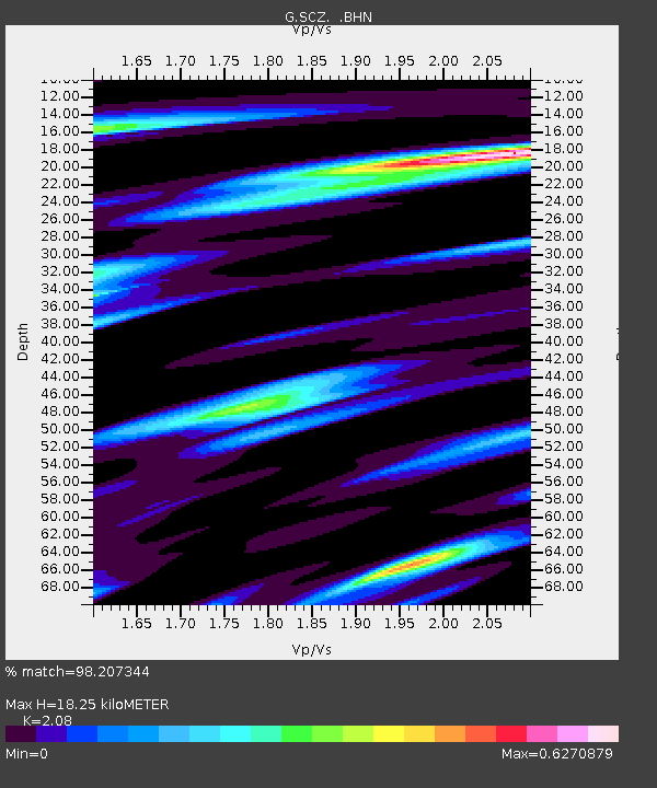
| Estimated Moho Depth: |
18.25 km |
| Estimated Crust Vp/Vs: |
2.08 |
| Assumed Crust Vp: |
6.391 km/s |
| Estimated Crust Vs: |
3.072 km/s |
| Estimated Crust Poisson's Ratio: |
0.35 |
|
| Radial Match: |
98.207344 % |
| Radial Bump: |
400 |
| Transverse Match: |
91.97898 % |
| Transverse Bump: |
400 |
| SOD ConfigId: |
3744 |
| Insert Time: |
2010-02-26 23:52:02.939 +0000 |
| GWidth: |
2.5 |
| Max Bumps: |
400 |
| Tol: |
0.001 |
|

Signal To Noise
| Channel | StoN | STA | LTA |
| G:SCZ: :BHN:20000328T11:11:50.700002Z | 1.2632033 | 3.7132818E-7 | 2.9395758E-7 |
| G:SCZ: :BHE:20000328T11:11:50.700002Z | 1.4920069 | 7.9151675E-7 | 5.3050474E-7 |
| G:SCZ: :BHZ:20000328T11:11:50.700002Z | 2.1374898 | 1.2759446E-6 | 5.9693593E-7 |
| Arrivals |
| Ps | 3.2 SECOND |
| PpPs | 8.6 SECOND |
| PsPs/PpSs | 12 SECOND |


