You are here: Home > Network List > NM - Cooperative New Madrid Seismic Network Stations List
> Station HDAR2 I40 Weigh Station,West Memphis,AR > Earthquake Result Viewer
HDAR2 I40 Weigh Station,West Memphis,AR - Earthquake Result Viewer
| Earthquake location: |
Ascension Island Region |
| Earthquake latitude/longitude: |
-10.4/-13.2 |
| Earthquake time(UTC): |
2014/05/16 (136) 21:11:29 GMT |
| Earthquake Depth: |
12 km |
| Earthquake Magnitude: |
4.9 MW |
| Earthquake Catalog/Contributor: |
ISC/ISC |
|
| Network: |
NM Cooperative New Madrid Seismic Network |
| Station: |
HDAR2 I40 Weigh Station,West Memphis,AR |
| Lat/Lon: |
35.15 N/90.09 W |
| Elevation: |
100 m |
|
| Distance: |
85.4 deg |
| Az: |
306.81 deg |
| Baz: |
106.024 deg |
| Ray Param: |
0.04476815 |
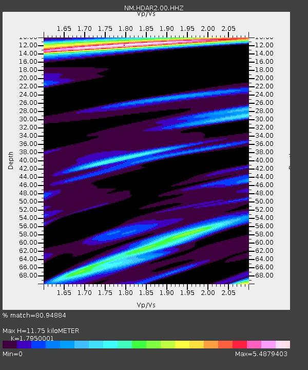
| Estimated Moho Depth: |
11.75 km |
| Estimated Crust Vp/Vs: |
1.80 |
| Assumed Crust Vp: |
6.273 km/s |
| Estimated Crust Vs: |
3.495 km/s |
| Estimated Crust Poisson's Ratio: |
0.27 |
|
| Radial Match: |
80.94884 % |
| Radial Bump: |
400 |
| Transverse Match: |
71.87203 % |
| Transverse Bump: |
400 |
| SOD ConfigId: |
3390531 |
| Insert Time: |
2019-04-11 22:14:39.327 +0000 |
| GWidth: |
2.5 |
| Max Bumps: |
400 |
| Tol: |
0.001 |
|

Signal To Noise
| Channel | StoN | STA | LTA |
| NM:HDAR2:00:HHZ:20140516T21:23:34.89001Z | 1.2561072 | 7.1985946E-6 | 5.730876E-6 |
| NM:HDAR2:00:HHN:20140516T21:23:34.89001Z | 1.0045509 | 9.065716E-6 | 9.024646E-6 |
| NM:HDAR2:00:HHE:20140516T21:23:34.89001Z | 1.6720703 | 1.2853193E-5 | 7.686994E-6 |
| Arrivals |
| Ps | 1.5 SECOND |
| PpPs | 5.1 SECOND |
| PsPs/PpSs | 6.6 SECOND |


