You are here: Home > Network List > TA - USArray Transportable Network (new EarthScope stations) Stations List
> Station R11A Troy Canyon, Currant, NV, USA > Earthquake Result Viewer
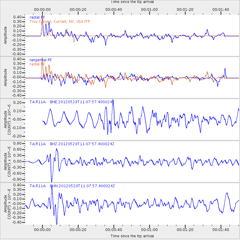
R11A Troy Canyon, Currant, NV, USA - Earthquake Result Viewer
*The percent match for this event was below the threshold and hence no stack was calculated.
| Earthquake location: |
Northern Italy |
| Earthquake latitude/longitude: |
44.9/11.0 |
| Earthquake time(UTC): |
2012/05/29 (150) 10:55:57 GMT |
| Earthquake Depth: |
6.8 km |
| Earthquake Magnitude: |
5.6 MB, 5.3 MS, 5.5 MW, 5.4 MW |
| Earthquake Catalog/Contributor: |
WHDF/NEIC |
|
| Network: |
TA USArray Transportable Network (new EarthScope stations) |
| Station: |
R11A Troy Canyon, Currant, NV, USA |
| Lat/Lon: |
38.35 N/115.59 W |
| Elevation: |
1756 m |
|
| Distance: |
84.2 deg |
| Az: |
320.613 deg |
| Baz: |
35.008 deg |
| Ray Param: |
$rayparam |
*The percent match for this event was below the threshold and hence was not used in the summary stack. |
|
| Radial Match: |
71.1265 % |
| Radial Bump: |
400 |
| Transverse Match: |
64.47996 % |
| Transverse Bump: |
400 |
| SOD ConfigId: |
455246 |
| Insert Time: |
2012-09-25 03:17:01.353 +0000 |
| GWidth: |
2.5 |
| Max Bumps: |
400 |
| Tol: |
0.001 |
|
Signal To Noise
| Channel | StoN | STA | LTA |
| TA:R11A: :BHZ:20120529T11:07:57.400024Z | 3.5693789 | 1.7445535E-7 | 4.887555E-8 |
| TA:R11A: :BHN:20120529T11:07:57.400024Z | 1.2535988 | 6.361488E-8 | 5.0745804E-8 |
| TA:R11A: :BHE:20120529T11:07:57.400024Z | 1.032486 | 5.8434797E-8 | 5.659621E-8 |
| Arrivals |
| Ps | |
| PpPs | |
| PsPs/PpSs | |


