You are here: Home > Network List > G - GEOSCOPE Stations List
> Station SCZ Chualar Canyon, Santa Cruz, California, U.S.A. > Earthquake Result Viewer
SCZ Chualar Canyon, Santa Cruz, California, U.S.A. - Earthquake Result Viewer
| Earthquake location: |
Andreanof Islands, Aleutian Is. |
| Earthquake latitude/longitude: |
51.6/-177.7 |
| Earthquake time(UTC): |
1999/03/20 (079) 10:47:45 GMT |
| Earthquake Depth: |
33 km |
| Earthquake Magnitude: |
6.3 MB, 6.8 MS, 6.9 MW, 6.8 ME |
| Earthquake Catalog/Contributor: |
WHDF/NEIC |
|
| Network: |
G GEOSCOPE |
| Station: |
SCZ Chualar Canyon, Santa Cruz, California, U.S.A. |
| Lat/Lon: |
36.60 N/121.40 W |
| Elevation: |
261 m |
|
| Distance: |
42.0 deg |
| Az: |
88.196 deg |
| Baz: |
309.207 deg |
| Ray Param: |
0.07334563 |
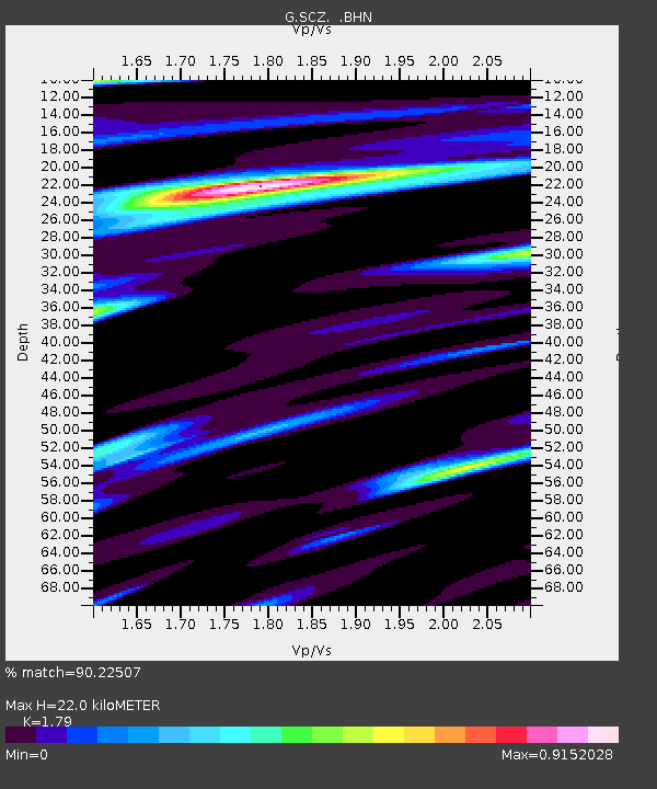
| Estimated Moho Depth: |
22.0 km |
| Estimated Crust Vp/Vs: |
1.79 |
| Assumed Crust Vp: |
6.391 km/s |
| Estimated Crust Vs: |
3.57 km/s |
| Estimated Crust Poisson's Ratio: |
0.27 |
|
| Radial Match: |
90.22507 % |
| Radial Bump: |
269 |
| Transverse Match: |
87.2935 % |
| Transverse Bump: |
336 |
| SOD ConfigId: |
4480 |
| Insert Time: |
2010-02-26 23:52:28.633 +0000 |
| GWidth: |
2.5 |
| Max Bumps: |
400 |
| Tol: |
0.001 |
|

Signal To Noise
| Channel | StoN | STA | LTA |
| G:SCZ: :BHN:19990320T10:55:03.802009Z | 5.0525126 | 2.4531205E-6 | 4.855249E-7 |
| G:SCZ: :BHE:19990320T10:55:03.802009Z | 1.5917711 | 7.7432986E-7 | 4.86458E-7 |
| G:SCZ: :BHZ:19990320T10:55:03.802009Z | 2.5887125 | 1.4033369E-6 | 5.420984E-7 |
| Arrivals |
| Ps | 2.9 SECOND |
| PpPs | 9.0 SECOND |
| PsPs/PpSs | 12 SECOND |


