You are here: Home > Network List > G - GEOSCOPE Stations List
> Station SCZ Chualar Canyon, Santa Cruz, California, U.S.A. > Earthquake Result Viewer
SCZ Chualar Canyon, Santa Cruz, California, U.S.A. - Earthquake Result Viewer
| Earthquake location: |
E. Russia-N.E. China Border Reg. |
| Earthquake latitude/longitude: |
43.6/130.4 |
| Earthquake time(UTC): |
1999/04/08 (098) 13:10:34 GMT |
| Earthquake Depth: |
566 km |
| Earthquake Magnitude: |
6.4 MB, 7.1 MW, 7.1 MW |
| Earthquake Catalog/Contributor: |
WHDF/NEIC |
|
| Network: |
G GEOSCOPE |
| Station: |
SCZ Chualar Canyon, Santa Cruz, California, U.S.A. |
| Lat/Lon: |
36.60 N/121.40 W |
| Elevation: |
261 m |
|
| Distance: |
77.0 deg |
| Az: |
51.664 deg |
| Baz: |
314.926 deg |
| Ray Param: |
0.04883659 |
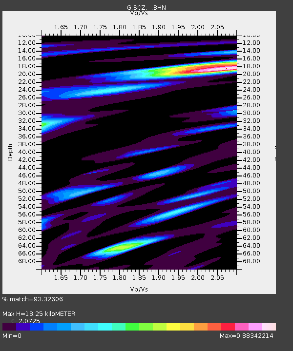
| Estimated Moho Depth: |
18.25 km |
| Estimated Crust Vp/Vs: |
2.07 |
| Assumed Crust Vp: |
6.391 km/s |
| Estimated Crust Vs: |
3.084 km/s |
| Estimated Crust Poisson's Ratio: |
0.35 |
|
| Radial Match: |
93.32606 % |
| Radial Bump: |
400 |
| Transverse Match: |
89.33148 % |
| Transverse Bump: |
400 |
| SOD ConfigId: |
4480 |
| Insert Time: |
2010-02-26 23:52:30.369 +0000 |
| GWidth: |
2.5 |
| Max Bumps: |
400 |
| Tol: |
0.001 |
|

Signal To Noise
| Channel | StoN | STA | LTA |
| G:SCZ: :BHN:19990408T13:20:58.069014Z | 23.72752 | 1.6210755E-5 | 6.832048E-7 |
| G:SCZ: :BHE:19990408T13:20:58.069014Z | 5.7538867 | 2.9556668E-6 | 5.136818E-7 |
| G:SCZ: :BHZ:19990408T13:20:58.069014Z | 8.154429 | 4.4116564E-6 | 5.410135E-7 |
| Arrivals |
| Ps | 3.1 SECOND |
| PpPs | 8.6 SECOND |
| PsPs/PpSs | 12 SECOND |


