You are here: Home > Network List > TA - USArray Transportable Network (new EarthScope stations) Stations List
> Station N59A State Game Land 141, Hazleton, PA, USA > Earthquake Result Viewer
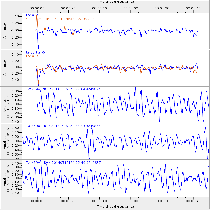
N59A State Game Land 141, Hazleton, PA, USA - Earthquake Result Viewer
*The percent match for this event was below the threshold and hence no stack was calculated.
| Earthquake location: |
Ascension Island Region |
| Earthquake latitude/longitude: |
-10.4/-13.2 |
| Earthquake time(UTC): |
2014/05/16 (136) 21:11:29 GMT |
| Earthquake Depth: |
12 km |
| Earthquake Magnitude: |
4.9 MW |
| Earthquake Catalog/Contributor: |
ISC/ISC |
|
| Network: |
TA USArray Transportable Network (new EarthScope stations) |
| Station: |
N59A State Game Land 141, Hazleton, PA, USA |
| Lat/Lon: |
40.92 N/75.77 W |
| Elevation: |
508 m |
|
| Distance: |
76.9 deg |
| Az: |
316.327 deg |
| Baz: |
116.317 deg |
| Ray Param: |
$rayparam |
*The percent match for this event was below the threshold and hence was not used in the summary stack. |
|
| Radial Match: |
62.004177 % |
| Radial Bump: |
400 |
| Transverse Match: |
60.264465 % |
| Transverse Bump: |
400 |
| SOD ConfigId: |
3390531 |
| Insert Time: |
2019-04-11 22:16:19.556 +0000 |
| GWidth: |
2.5 |
| Max Bumps: |
400 |
| Tol: |
0.001 |
|
Signal To Noise
| Channel | StoN | STA | LTA |
| TA:N59A: :BHZ:20140516T21:22:49.924983Z | 0.9547439 | 2.332579E-7 | 2.443146E-7 |
| TA:N59A: :BHN:20140516T21:22:49.924983Z | 2.119597 | 3.0069293E-7 | 1.4186327E-7 |
| TA:N59A: :BHE:20140516T21:22:49.924983Z | 0.6601055 | 1.06331974E-7 | 1.6108329E-7 |
| Arrivals |
| Ps | |
| PpPs | |
| PsPs/PpSs | |


